My prayers are with all the families, friends and businesses in all areas!
Warnings have been activated!
Make last minute preparations, and evacuate immediately. Please, for your own safety, get out NOW!!! Hurricane Ian is making it’s move to make a landfall to the Gulf Coast and Panhandle areas of Florida. This has been a light hurricane season, so far. However, this storm is not fooling around!! This is a very serious storm, so take proper preparation now. Be ready for storm surge, high winds, power outages and possible tornadoes. Do NOT sit this one out! Evacuate immediately!! Visit: The NOAA NWS National Hurricane Center’s Facebook page for more info. More technical information as provided by cdema.org – Tropical Weather Systems.
The current tropical activity report directly from the NOAA NWS National Hurricane Center:

Atlantic Tropical Report: Warnings have been activated! Hurricane Ian is due for landfall on the Gulf Coast. . .See information below and make preparations immediately!!!
The Atlantic season for the year 2022 has been a less than active year so far, until now with Hurricane Ian. There are three tropical regions now, including Hurricane Ian, now at the Cuba; and then poised for landfall in the Florida Gulf Coast and Panhandle areas–sometime starting THIS evening to middle of the night, between 18 hours to 36 hours from now. The storm is moving toward the northwest near 16 mph and should continue through late Tuesday to early Wednesday. A busy day ALL day today, tomorrow and Thursday–See more information below.
HURRICANE IAN: Warnings have been activated! Check out for your local listings here: Nationwide Station Listing Using Broadcast Frequencies. Get ready…start preparing for landfall right away!! Take proper preparation now, and evacuate immediately. Do not think you can sit this one out. Very warm waters of the Gulf may render further development of this storm. Be ready early, and have an emergency evacuation protocol in place, Be ready for storm surge, flooding rains, high winds, power outages and possible tornadoes. Winds could have a detrimental effect on impending danger and care needs to be exercised. It is important to exercise extra special care in those regions. Have an escape plan in place. Residents in all areas should have a hurricane plan in action or visit https://www.weather.gov/wrn/hurricane-preparedness. Please adhere to safety measures and stay out of the way of danger! Make arrangements accordingly.
 NOAA NWS National Hurricane Center on Facebook
…IAN CONTINUES TO QUICKLY INTENSIFY…
…CONDITIONS IN WESTERN CUBA TO DETERIORATE THIS EVENING AND TONIGHT WITH SIGNIFICANT WIND AND STORM SURGE IMPACTS EXPECTED…
At 500 PM EDT (2100 UTC), the center of Hurricane Ian was located about 155 miles southeast of the western tip of Cuba. Ian is moving toward the north-northwest near 13 mph (20 km/h). A turn toward the north with a slightly slower forward speed is expected on Tuesday. A turn toward the north-northeast with a further reduction in forward speed is forecast on Wednesday. On the forecast track, the center of Ian is expected to move near or over western Cuba tonight and early Tuesday. Ian will then emerge over the southeastern Gulf of Mexico on Tuesday, pass west of the Florida Keys late Tuesday, and approach the west coast of Florida on Wednesday into Thursday.
Maximum sustained winds have increased to near 100 mph (155 km/h) with higher gusts. Rapid strengthening is expected during the next day or so, and Ian is forecast to become a major hurricane tonight or early Tuesday when it is near western Cuba and remain a major hurricane over the southeastern Gulf of Mexico on Wednesday.
Hurricane-force winds extend outward up to 35 miles (55 km) from the center and tropical-storm-force winds extend outward up to 115 miles
(185 km).
The estimated minimum central pressure is 972 mb (28.71 inches).
Visit the National Hurricane Center website at hurricanes.gov for additional forecast information on Ian.
The next intermediate advisory will be at 8:00 PM EDT, followed by the next complete advisory at 11:00 PM EDT. – www.hurricanes.gov
Courtesy of @NWSNHC on Facebook
🌀 🌀 🌀 🌀 🌀 🌀 🌀 🌀 🌀 🌀 🌀 🌀 🌀 🌀
La Niña is being watched right now, with likelihood of ENSO Neutral development. THis year is up in the air, and markedly quieter conditions warrant that we are indeed likely to end up in an ENSO Neutral over this winter season. Eyes are on the occurrence of where the year is on the stage of ocean water warmth in the mid-Pacific region. KEEPING SAFETY IS OF UPMOST CONCERN! Check back for further updates.
HURRICANE IAN
🌀 🌀 🌀 🌀 🌀 🌀 🌀 🌀 🌀 🌀 🌀 🌀 🌀 🌀
See Tips: Preparedness Before, During & After Tropical Weather:
The Danger of Hurricanes & Tropical Activity – Summer & Fall Weather Series + Resources For Recovery https://t.co/ape7EquF9O
— Jerry Marquardt (@Versatileer) June 5, 2022
Click here if Twitter widget does not show
Be prepared, and be safe.
RESOURCES:
Versatileer Weather Page:

Tropical Activity & Wildfires Report, Tropical Systems-Atlantic & Pacific + wildfire forecasts:
![]()
Hurricane Preparedness Kit, courtesy of the Ward Law Group: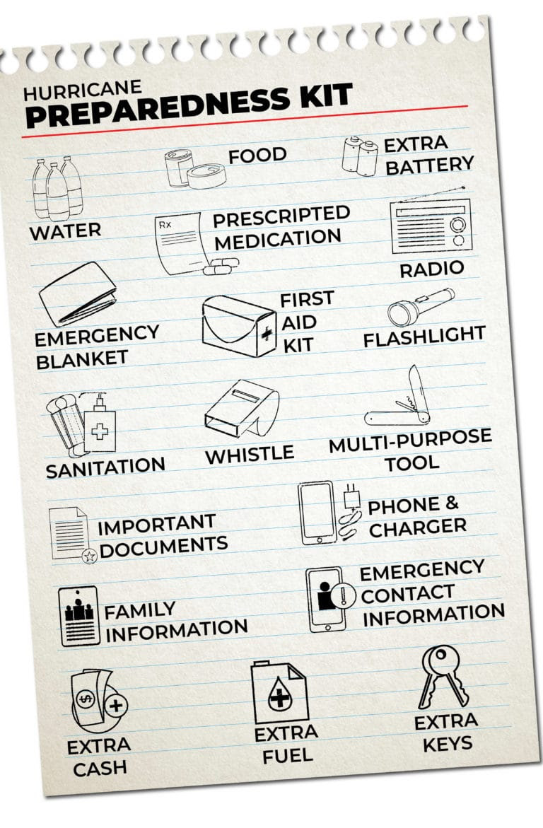
FIND YOUR LOCAL NOAA.com WEATHER RADIO STATION:
FIND YOUR LOCAL NATIONAL WEATHER SERVICE FORECAST:

STAY SAFE!!!
Widget not in any sidebars