My prayers are with all the families, friends and businesses in all areas!
Warnings have been activated!
This is NOT over yet!!If you have evacuated, stay away until authorities give an all-clear. If you have not, do not venture out into the storm, even if the winds stop–for your own safety!!! Often times people who have not evacuated, venture out into the eye of the storm. This can be a big mistake, as the winds on the back side of the storm can be deadly ones, and the winds pick up within seconds– the most powerful ones in the whole hurricane! , Venturing too fat from safety can put you in a spot you cannot back out of. Furthermore, flooding waters cover and put risk of injury in a very likely position. A lot of times, even hospitals could be locked down because of the storm. Sit tight, and wait for the end of the whole storm–and wait for assistance.
Category 4 Hurricane Ian has made landfall, moving inland. The epicenter of the eye moved inland near Cayo Costa, in southwest Florida near a protected barrier island just west of highly populated Fort Myers. This storm is rated as one of the most powerful storms ever recorded in the U.S., and the storm is still swamping streets with flooding water and smashing and snapping trees along the coast, while moving at a snail’s pace that continues to threaten catastrophic flooding across a wide area. It is reported that barely an hour after this massive storm came ashore, a coastal sheriff’s office reports that it had already gotten a significant number of calls from trapped persons inside homes.
This is a very serious and terrifying storm, and it is not completely over yet, so continue to take proper precaution now. Be ready for more storm surge, more high winds, more power outages and more possible tornadoes. Please follow instructions for proper return after the storm! Continue evacuation orders!! Visit: The NOAA NWS National Hurricane Center’s Facebook page for more info. More technical information as provided by cdema.org – Tropical Weather Systems.
The current tropical activity report directly from the NOAA NWS National Hurricane Center:
↓ At 3:19 pm ↓
YouTube Video of radar of Hurricane Ian moving up to Florida and the eye crossing onto land:
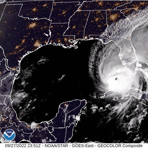
The current Satellite zoom of the Caribbean/Gulf view, plus full Earth images from NOAA/NESDIS/STAR:

🌀 🌀 🌀 🌀 🌀 🌀 🌀 🌀
 NOAA NWS National Hurricane Center on Facebook
Courtesy of @NWSNHC on Facebook
Atlantic Tropical Report: Warnings have been activated! Category 4 Hurricane Ian has made it’s landfall on the Gulf Coast near Cayo Costa, Florida, coming in moving north/northeast. . . .Also a tropical depression, number eleven, see report below. Stay prepared, it is NOT over!!!
The Atlantic season for the year 2022 has been a less than active year so far, until now with Category 4 Hurricane Ian. There are two tropical regions now, including Hurricane Ian, now Having moved inland into Florida; and is moving with snails pace forward movement. This slow movement is going to cause way more flooding than the usual faster paced storm would. It is poised to move just east of the Atlantic, then forecast to move inland near Georgia–sometime now to Friday, before it becomes extra-tropical. A busy week, and the slower it moves the more flooding–today, tomorrow and Friday–See more information below on other activity. – www.hurricanes.gov
CATEGORY 4 HURRICANE IAN: Warnings have been activated! Check out for your local listings here: Nationwide Station Listing Using Broadcast Frequencies. If you have not evacuated, stay indoors, stay away from basements…do not venture out for any reason!! Very warm waters of the Gulf are feeding the energy of this storm, further development of this storm is possible. Be ready for more peril, and have an emergency evacuation protocol in place, Be ready for more storm surge, more flooding rains, more high winds, more power outages and more possible tornadoes. Winds could have a detrimental effect on impending danger and care needs to be exercised. It is important to exercise extra special care in those regions. Have an escape plan in place. Residents in all areas should have a hurricane plan in action or visit https://www.weather.gov/wrn/hurricane-preparedness. Please adhere to safety measures and stay out of the way of danger! Make arrangements accordingly.
NOAA NWS National Hurricane Center on Facebook…IAN BATTERING THE FLORIDA PENINSULA WITH CATASTROPHIC STORM SURGE, WINDS, AND FLOODING…
…NEW WATCHES AND WARNINGS ISSUED FOR NORTH AND SOUTH CAROLINA…
At 500 PM EDT (2100 UTC), the eye of Hurricane Ian was located about 5 miles east of Punta Gorda, Florida. Ian is moving toward the north-northeast near 8 mph (13 km/h). On the forecast track, the center of Ian is expected to move across central Florida tonight and Thursday morning and emerge over the western Atlantic by late Thursday. Ian is forecast to turn northward on Friday and approach the northeastern Florida coast, Georgia and South Carolina coasts late Friday.
Maximum sustained winds have decreased to near 140 mph (220 km/h) with higher gusts. Ian is a category 4 hurricane on the Saffir-Simpson Hurricane Wind Scale. Further weakening is
expected for the next day or so, but Ian could be near hurricane strength when it moves over the Florida East coast tomorrow, and when it approaches the northeastern Florida, Georgia and South Carolina coasts late Friday.
Hurricane-force winds extend outward up to 50 miles (85 km) from the center and tropical-storm-force winds extend outward up to 175 miles
(280 km). A WeatherFlow station in Grove City recently reported sustained winds of 95 mph (153 km/h) and a wind gust of 128 mph (208 km/h). A University of Florida Coastal Monitoring Program wind tower recently reported sustained winds of 89 mph (143 km/h) with a gust to 114 mph (183 km/h).
The estimated minimum central pressure is 945 mb (27.91 inches).
Visit the National Hurricane Center website at hurricanes.gov for additional forecast information on Ian.
The next intermediate advisory will be at 8:00 PM EDT, followed by the next complete advisory at 11:00 PM EDT. – www.hurricanes.gov
Courtesy of @NWSNHC on Facebook
🌀 🌀 🌀 🌀 🌀 🌀 🌀 🌀 🌀 🌀 🌀 🌀 🌀 🌀
La Niña is being watched right now, with likelihood of ENSO Neutral development. THis year is up in the air, and markedly quieter conditions warrant that we are indeed likely to end up in an ENSO Neutral over this winter season. Eyes are on the occurrence of where the year is on the stage of ocean water warmth in the mid-Pacific region. KEEPING SAFETY IS OF UPMOST CONCERN! Check back for further updates.
CATEGORY 4 HURRICANE IAN
🌀 🌀 🌀 🌀 🌀 🌀 🌀 🌀 🌀 🌀 🌀 🌀 🌀 🌀
See Tips: Preparedness Before, During & After Tropical Weather:
The Danger of Hurricanes & Tropical Activity – Summer & Fall Weather Series + Resources For Recovery https://t.co/ape7EquF9O
— Jerry Marquardt (@Versatileer) June 5, 2022
Click here if Twitter widget does not show
Be prepared, and be safe.
RESOURCES:
Versatileer Weather Page:

Tropical Activity & Wildfires Report, Tropical Systems-Atlantic & Pacific + wildfire forecasts:
![]()
Hurricane Preparedness Kit, courtesy of the Ward Law Group: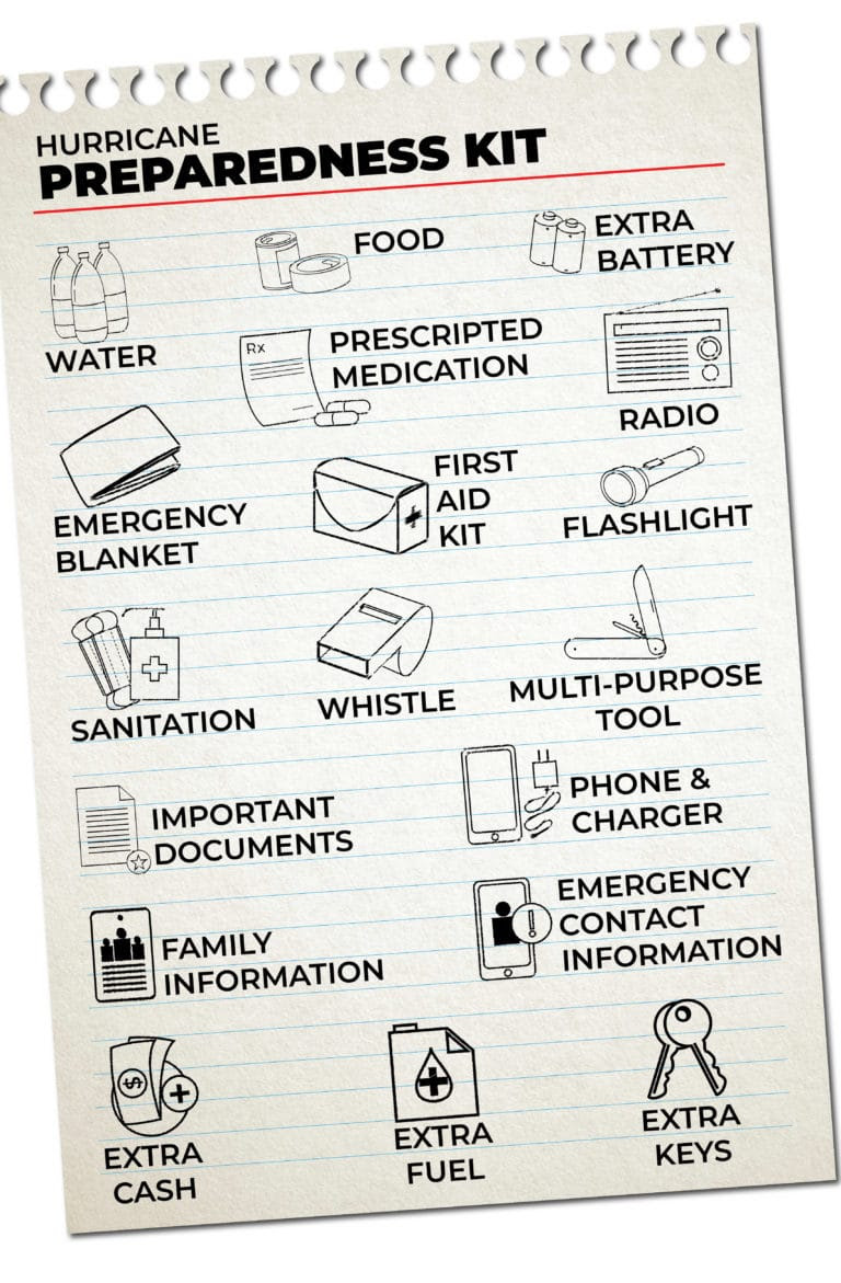
FIND YOUR LOCAL NOAA.com WEATHER RADIO STATION:
FIND YOUR LOCAL NATIONAL WEATHER SERVICE FORECAST:

Image courtesy of OpenWeatherMap.org
STAY SAFE!!!
Widget not in any sidebars
More on Versatileer:
 International Women's Day Celebration – 202303/09/2023
 Photo of the Day: 11/10/19 – Los Angeles at Distance From a Lookout Point in Griffith Park on Hazy D...11/10/2019
 Happy Love Your Pets Day – 202302/20/2023
 From the Satellite...Tropical Storm Beta on .GIPHY09/26/2020
 Featured Photo: Flower of the Day – Silver Spiraea09/28/2021

Crazy picture and this did a lot of damage!