My prayers are with all the families, friends and businesses in all areas!
Warnings have been activated!
This is NOT over yet!! Another landfall is imminent!! Florida: If you have evacuated, always get an all-clear before returning, due to safety. If you have not evacuate, do not venture out into the storm until you get an all-clear, due to safety concerns!!! Often times people who have not evacuated, venture out into unsafe streets. With flooding waters, it is easy to find danger without even knowing you could be in a dangerous area. If you are evacuated, returning to your home area too soon can be tragic if the area is still too dangerous to go back into. Sit tight, and wait for the end of the whole storm.
Category 4 Hurricane, now an official Hurricane Ian again wreaked havoc, and continues to pour more rain being downgraded to a tropical storm. The epicenter of the eye moved inland yesterday morning, near Cayo Costa, in southwest Florida near a protected barrier island just west of highly populated Fort Myers. This storm is rated estimated to be the fourth worst storm ever recorded in the State of Florida, and right now, not being quite over yet, all statistics are still being tabulated. Now it is poised for a second landfall, with many projections based on different scenarios of how upper level winds will steer the storm.
When Florida moves into the clean-up stage, people are going to need some resources in order to recover. See my post: The Danger of Hurricanes & Tropical Activity – Summer & Fall Weather Series + Resources For Recovery.
This is and has been a very serious and terrifying storm, and it is not completely over yet, so continue to take proper precaution now. Be ready for yet more storm surge, more high winds, more power outages and more possible tornadoes. Please follow instructions for proper return after the storm! Continue evacuation orders!! Visit: The NOAA NWS National Hurricane Center’s Facebook page for more info. More technical information as provided by cdema.org – Tropical Weather Systems.
Please stay tuned: The complete video sets to follow on future posts, and update of “From The Eye In the Sky” .GIF video via .GIPHY, of the complete breeding of Hurricane Ian all the way from the beginning to end!
The current tropical activity report directly from the NOAA NWS National Hurricane Center:
↓ At 11:00 pm ↓
YouTube Video of radar of Hurricane Ian moving through the Florida mainland:
The current Satellite zoom of the Caribbean/Gulf view, plus full Earth images from NOAA/NESDIS/STAR:


🌀 🌀 🌀 🌀 🌀 🌀 🌀 🌀
 NOAA NWS National Hurricane Center on Facebook
Courtesy of @NWSNHC on Facebook
Atlantic Tropical Report: Warnings have been activated! Category 4 Hurricane, now again official Hurricane Ian, had made it’s Florida landfall on the Gulf Coast near Cayo Costa, coming in moving north/northeast towards another up in the air landfall on the middle-Eastern Seaboard. . .Also a tropical depression, number eleven, is breaking up way east, see report below. Stay prepared, it is NOT over!!!
The Atlantic season for the year 2022 has been a less than active year so far, until now with Category 4 Hurricane, now again official Hurricane Ian. There are two tropical regions now, including Hurricane Ian, now Having moved inland into Florida; and is moving with snails pace forward movement. This slow movement is going to cause way more flooding than the usual faster paced storm would. It is poised to move just east of the Atlantic, then forecast to move inland near Georgia–sometime now to Friday, before it becomes extra-tropical. A busy week, and the slower it moves the more flooding–today, tomorrow and Friday–See more information below on other activity. – www.hurricanes.gov
AGAIN HURRICANE IAN: New warnings are in the process of being been activated! Check out for your local listings here: Nationwide Station Listing Using Broadcast Frequencies. If you have not evacuated, stay indoors, stay away from basements…do not venture out for any reason!! Very warm waters of the Gulf and Atlantic Oceans are feeding the energy of this storm, further development of this storm is possible. Be ready for more peril, and have an emergency evacuation protocol in place, Be ready for more storm surge, more flooding rains, more high winds, more power outages and more possible tornadoes. Winds could have a detrimental effect on impending danger and care needs to be exercised. It is important to exercise extra special care in those regions. Have an escape plan in place. Residents in all areas should have a hurricane plan in action or visit https://www.weather.gov/wrn/hurricane-preparedness. Please adhere to safety measures and stay out of the way of danger! Make arrangements accordingly.
NOAA NWS National Hurricane Center on Facebook…IAN BECOMES A HURRICANE AGAIN…
…TAKING AIM AT THE CAROLINAS AND GEORGIA WITH LIFE-THREATENING FLOODING, STORM SURGE AND STRONG WINDS…
At 500 PM EDT (2100 UTC), the center of Hurricane Ian was located about 240 miles south of Charleston, South Carolina. Ian is moving toward the north-northeast near 10 mph (17 km/h). A turn toward the north is expected tonight, followed by a turn toward the north-northwest with an increase in forward speed Friday night. On the forecast track, Ian will approach the coast of South Carolina on Friday. The center will move farther inland across the Carolinas Friday night and Saturday.
Maximum sustained winds have increased to near 75 mph (120 km/h) with higher gusts. Ian could slightly strengthen before landfall tomorrow, and is forecast to rapidly weaken over the southeastern United States late Friday into Saturday.
Hurricane-force winds extend outward up to 45 miles (75 km) from the center, and tropical-storm-force winds extend outward up to 415 miles (665 km). Kennedy Space Center Tower 1 recently reported a wind gust to 89 mph (145 km/h).
The estimated minimum central pressure is 986 mb (29.12 inches).
Visit the National Hurricane Center website at hurricanes.gov for additional forecast information on Ian.
The next intermediate advisory will be at 8:00 PM EDT, followed by the next complete advisory at 11:00 PM EDT. – www.hurricanes.gov
Courtesy of @NWSNHC on Facebook
🌀 🌀 🌀 🌀 🌀 🌀 🌀 🌀 🌀 🌀 🌀 🌀 🌀 🌀
La Niña is being watched right now, with likelihood of ENSO Neutral development. This year is up in the air, and markedly quieter conditions warrant that we are indeed likely to end up in an ENSO Neutral over this winter season. Eyes are on the occurrence of where the year is on the stage of ocean water warmth in the mid-Pacific region. KEEPING SAFETY IS OF UPMOST CONCERN! Check back for further updates.
HURRICANE IAN
🌀 🌀 🌀 🌀 🌀 🌀 🌀 🌀 🌀 🌀 🌀 🌀 🌀 🌀
See Tips: Preparedness Before, During & After Tropical Weather:
The Danger of Hurricanes & Tropical Activity – Summer & Fall Weather Series + Resources For Recovery https://t.co/ape7EquF9O
— Jerry Marquardt (@Versatileer) June 5, 2022
Click here if Twitter widget does not show
Be prepared, and be safe.
RESOURCES:
Versatileer Weather Page:

Tropical Activity & Wildfires Report, Tropical Systems-Atlantic & Pacific + wildfire forecasts:
![]()
Hurricane Preparedness Kit, courtesy of the Ward Law Group: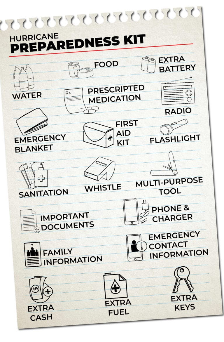
FIND YOUR LOCAL NOAA.com WEATHER RADIO STATION:
FIND YOUR LOCAL NATIONAL WEATHER SERVICE FORECAST:

Image courtesy of OpenWeatherMap.org
STAY SAFE!!!
Widget not in any sidebars


Scary, scary, scary! I saw the video on the Weather Channel, OMG! Now it’s going to hit the Carolinas and then move up the I-95 corridor. Prayers for all!