My prayers are with all the families, friends and businesses in all areas!
Warnings still in place!
Stay evacuated until “all clear” has been issued, for your own safety. It is not safe to return NOW!!! Atlantic Hurricane Beryl has made landfall at 4 a.m. CDT near Matagorda, Texas with maximum sustained winds of 80 mph, classifying it as a Category 1 hurricane. The Texas coast experienced wind gusts of over 90 mph in Freeport and San Bernard this morning, with Houston seeing gusts of up to 84 mph at Hobby airport, leading to widespread power outages. Additionally, moderate to locally major coastal flooding from storm surge has been reported on parts of the middle and upper Texas coasts. Rainfall totals in the Houston metro area over the past 24 hours range from 5 to 8 inches. Areas of the United States including Texas, Louisiana, Arkansas, Oklahoma, Missouri, Tennessee, Kentucky and Illinois; and remnants of the hurricane will result in extra-tropical rains to Indiana, Wisconsin, Michigan, Ohio, Pennsylvania, and New York–before moving into Canada. Atlantic Hurricane Beryl is the first hurricane of the 2024 Atlantic hurricane season, a storm that with its history, quickly intensified into a Category 5 storm very unusually early in the year. This rapid intensification was partly driven by abnormally warm ocean temperatures. These high temperatures were one of the contributing factors to NOAA’s forecast in May of an 85% likelihood that the 2024 Atlantic hurricane season would be more active than usual. Atlantic Hurricane Beryl made history by becoming the earliest Category 5 in the whole 100 years of record keeping (Hurricane Emily was the strongest Atlantic hurricane in that month in 2005: which recorded maximum sustained winds of 160mph), and the Category 4 Atlantic hurricane record, surpassing Hurricane Dennis which achieved Category 4 status on July 8, 2005. The effects of Hurricane Beryl have devastated the Caribbean including Mexico’s Yucatan peninsula, Jamaica, Barbados, Grenada, and Trinidad and Tobago, with these regions experiencing the full force of the storm on Monday. St. Vincent, the Grenadines, and Grenada. This continues to be a very serious storm, so take proper preparation now. Be ready for storm surge, high winds, power outages and possible tornadoes. Visit: The NOAA NWS National Hurricane Center’s Facebook page for more info. More technical information as provided by cdema.org – Tropical Weather Systems.
Current tropical activity report directly from NOAA NWS National Hurricane Center & OWM:
| Atlantic Hurricane Beryl – 07/08/2024 | ||||
 07/08/24 at 3:54 am 07/08/24 at 3:54 am |
||||
|
Information Courtesy of National Hurricane Center/NOAA |
||||
| See Video on YouTube:
07/07/24 to 07/08/24 |
||||
|
Radar Loop courtesy of openweathermap.org / Video Caption © 2024 Versatileer |
 NOAA NWS National Hurricane Center on Facebook
Final Update on Tropical Storm Beryl from NHC in Miami, FL (July 8, 2024)
National Hurricane Center Director Dr. Michael Brennan provides the final update on Tropical Storm Beryl. As the hurricane season continues, the time to prepare is now! The Atlantic hurricane season runs until November 30.
Follow us on social media to get the latest updates! Stay tuned for posts during tropical events and LIVE updates on Facebook, YouTube, and Instagram!
Facebook & YouTube – @ NOAA/NWS National Hurricane Center
Instagram – @ nwsnhc_hurricanes
X – @ NWSNHC
For more detailed forecasts and text updates, visit hurricanes.gov.
******************************
NOAA/National Weather Service
National Hurricane Center
Miami, FLPosted by NOAA NWS National Hurricane Center on Monday, July 8, 2024
10am CDT Key Messages for #TropicalStorm #Beryl: Life threatening storm surge, damaging wind gusts and considerable flash flooding continue across portions of southeast #Texas. See https://t.co/tW4KeGe9uJ and https://t.co/SiZo8oA90V for more info and the latest updates pic.twitter.com/lzfmaN3Cmt
— National Hurricane Center (@NHC_Atlantic) July 8, 2024
NHC OFFICIAL INFO: Official Information for Hurricane Beryl ❖ PDF
[NOTES]…
Key Messages for Tropical Storm Beryl Advisory 40: 10:00 AM CDT Mon Jul 08, 2024
1. Life-threatening storm surge inundation will continue through this afternoon along the coast of Texas from Port O’Connor to Sabine Pass, including
the eastern portion of Matagorda Bay and Galveston Bay.
2. Damaging wind gusts near the core of Beryl will continue to spread northward within the Tropical Storm Warning area, including the Houston metro area, for the next several hours.
3. Considerable flash and urban flooding is expected today into tonight across portions of the middle and upper Texas Gulf Coast and eastern Texas. Minor to isolated major river flooding is also expected.
4. Rip currents will cause life-threatening beach conditions through Tuesday across portions of the northern and western Gulf coasts. Beachgoers should heed warning flags and the advice of lifeguards and local officials before venturing into the water.
10am CDT Key Messages for #TropicalStorm #Beryl: Life threatening storm surge, damaging wind gusts and considerable flash flooding continue across portions of southeast #Texas. See hurricanes.gov and weather.gov for more info and the latest updates
Pacific Tropical Report: Tropical cyclone activity is not expected during the next 48 hours.
No flooding or other activity in the Pacific.

ATLANTIC HURRICANE BERYL
🌀 🌀 🌀 🌀 🌀 🌀 🌀 🌀 🌀 🌀 🌀 🌀 🌀 🌀
See Tips: Preparedness Before, During & After Tropical Weather:
The Danger of Hurricanes & Tropical Activity ’24 – Summer & Fall Weather Series + Resources
The Danger of Floods ’24 – Spring & Summer Weather Series + Resources
The Danger of High Winds ’24 – Spring & Summer Weather Series + Resources
The Danger of Tornadoes ’24 – Spring & Summer Weather Series + Resources
Be prepared, and be safe.
🌀 🌀 🌀 🌀 🌀 🌀 🌀 🌀 🌀 🌀 🌀 🌀 🌀 🌀
MORE RESOURCES:
Versatileer WEATHER PAGE:![]() Versatileer PREPAREDNESS/COMMONSENSE TIPS & POINTERS:
Versatileer PREPAREDNESS/COMMONSENSE TIPS & POINTERS:

Tropical Activity & Wildfires Report, Tropical Systems-Atlantic & Pacific + wildfire forecasts:
![]()
Hurricane Preparedness Kit, courtesy of the Ward Law Group: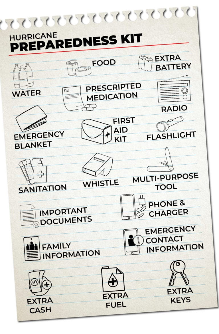
FIND YOUR LOCAL NOAA.com WEATHER RADIO STATION:
FIND YOUR LOCAL NATIONAL WEATHER SERVICE FORECAST:
ENERGY USAGE CALCULATOR: Interactive comparison tool courtesy of Energy Use Calculator: energyusecalculator.com
![]() ENERGY USAGE CALCULATOR: Interactive comparison tool courtesy of saveonenergy.com
ENERGY USAGE CALCULATOR: Interactive comparison tool courtesy of saveonenergy.com
GUIDE TO ASBESTOS & DISASTER: What to know during natural disasters![]()
STAY SAFE!!!
☀️ Current Weather
Click Blue Button
More on Versatileer:
![Solar Eclipse at Sunrise This Morning – Info On Future Solar Eclipses]()
Solar Eclipse at Sunrise This Morning – Info On Future Solar Eclipses
06/10/2021![Birthday Cake.jpg]()
Happy National Cake Day – 2025
11/26/2025![Smoke XII.jpg]()
World No Tobacco Day – 2025 + Treatment Resources
05/31/2025![20211219_210242.jpg]()
Featured Photos: The 25 Days of Christmas – Bonus Photo 2: Yuletide Celebration of the 70th Annivers...
12/26/2021![20220211_205347.jpg]()
Featured Photo: Magic Days of St. Valentine – Cupid on 154th Street, Oak Forest
02/12/2022


Be safe everyone