My prayers are with all the families, friends and businesses in all areas!
Warnings have been activated!
Make last minute preparations, and evacuate immediately. Please, for your own safety, get out NOW!!! Atlantic Hurricane Beryl’s future path of the storm looks centered on the path of a direct hit for Brownsville, Texas. Areas of the United States including Texas, Louisiana, Arkansas and Oklahoma should take prepations and have an evacuation plan right away. Atlantic Hurricane Beryl is the first hurricane of the 2024 Atlantic hurricane season, quickly intensified into a Category 5 storm very unusually early in the year. This rapid intensification was partly driven by abnormally warm ocean temperatures. These high temperatures were one of the contributing factors to NOAA’s forecast in May of an 85% likelihood that the 2024 Atlantic hurricane season would be more active than usual. Atlantic Hurricane Beryl made history by becoming the earliest Category 5 in the whole 100 years of record keeping (Hurricane Emily was the strongest Atlantic hurricane in that month in 2005: which recorded maximum sustained winds of 160mph), and the Category 4 Atlantic hurricane record, surpassing Hurricane Dennis which achieved Category 4 status on July 8, 2005. The effects of Hurricane Beryl have devastated the Caribbean including Mexico’s Yucatan peninsula, Jamaica, Barbados, Grenada, and Trinidad and Tobago, with these regions experiencing the full force of the storm on Monday. St. Vincent, the Grenadines, and Grenada. This is a very serious storm, so take proper preparation now. Be ready for storm surge, high winds, power outages and possible tornadoes. Visit: The NOAA NWS National Hurricane Center’s Facebook page for more info. More technical information as provided by cdema.org – Tropical Weather Systems.
The current tropical activity report directly from the NOAA NWS National Hurricane Center:
| Atlantic Hurricane Beryl – 07/05/2024 | ||||
 07/05/24 at 9:49 am 07/05/24 at 9:49 am |
||||
|
Information Courtesy of National Hurricane Center/NOAA |
 NOAA NWS National Hurricane Center on Facebook
Morning Update on Hurricane Beryl from NHC in Miami, FL (July 5, 2024)
National Hurricane Center Director Dr. Michael Brennan provides the latest updates on Hurricane Beryl. As the hurricane season continues, the time to prepare is now! The Atlantic hurricane season runs until November 30.
Follow us on social media to get the latest updates! Stay tuned for posts during tropical events and LIVE updates on Facebook, YouTube, and Instagram!
Facebook & YouTube – @ NOAA/NWS National Hurricane Center
Instagram – @ nwsnhc_hurricanes
X – @ NWSNHC
For more detailed forecasts and text updates, visit hurricanes.gov.
******************************
NOAA/National Weather Service
National Hurricane Center
Miami, FLPosted by NOAA NWS National Hurricane Center on Friday, July 5, 2024
Here are the 10 am CDT Key Messages on Hurricane #Beryl. There is an increasing risk of hurricane-force winds, life threatening storm surge, and flooding for portions of northeast Mexico and the lower-middle Texas coast late Sunday and Monday. https://t.co/tW4KeGe9uJ pic.twitter.com/hTrYfEy8Ll
— National Hurricane Center (@NHC_Atlantic) July 5, 2024
NHC OFFICIAL INFO: Official Information for Hurricane Beryl ❖ PDF
[NOTES]…
Pacific Tropical Report: Tropical Depression Aletta: …ALETTA EXPECTED TO BECOME A REMNANT LOW LATER TODAY OR TONIGHT… 8:00 AM MST Fri Jul 5 Location: 18.8°N 109.8°W Moving: W at 12 mph Min pressure: 1006 mb Max sustained: 35 mph. Residents in all areas should have a hurricane plan in action or visit https://www.weather.gov/wrn/
No flooding or other activity other than at sea expected in the Pacific.

ATLANTIC HURRICANE BERYL
🌀 🌀 🌀 🌀 🌀 🌀 🌀 🌀 🌀 🌀 🌀 🌀 🌀 🌀
See Tips: Preparedness Before, During & After Tropical Weather:
The Danger of Hurricanes & Tropical Activity ’24 – Summer & Fall Weather Series + Resources
The Danger of Floods ’24 – Spring & Summer Weather Series + Resources
The Danger of High Winds ’24 – Spring & Summer Weather Series + Resources
The Danger of Tornadoes ’24 – Spring & Summer Weather Series + Resources
Be prepared, and be safe.
🌀 🌀 🌀 🌀 🌀 🌀 🌀 🌀 🌀 🌀 🌀 🌀 🌀 🌀
MORE RESOURCES:
Versatileer WEATHER PAGE:![]() Versatileer PREPAREDNESS/COMMONSENSE TIPS & POINTERS:
Versatileer PREPAREDNESS/COMMONSENSE TIPS & POINTERS:

Tropical Activity & Wildfires Report, Tropical Systems-Atlantic & Pacific + wildfire forecasts:
![]()
Hurricane Preparedness Kit, courtesy of the Ward Law Group: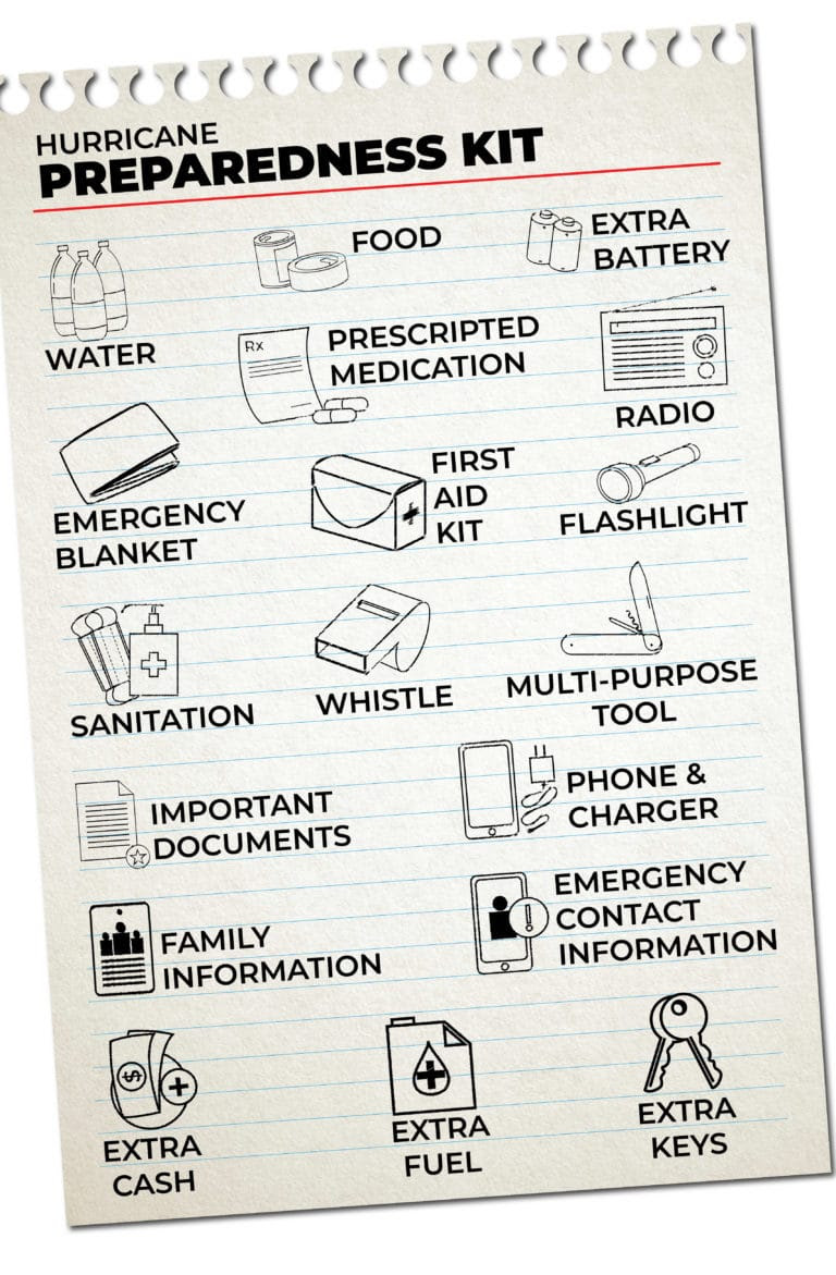
FIND YOUR LOCAL NOAA.com WEATHER RADIO STATION:
FIND YOUR LOCAL NATIONAL WEATHER SERVICE FORECAST:
ENERGY USAGE CALCULATOR: Interactive comparison tool courtesy of Energy Use Calculator: energyusecalculator.com
![]() ENERGY USAGE CALCULATOR: Interactive comparison tool courtesy of saveonenergy.com
ENERGY USAGE CALCULATOR: Interactive comparison tool courtesy of saveonenergy.com
GUIDE TO ASBESTOS & DISASTER: What to know during natural disasters![]()
STAY SAFE!!!
☀️ Current Weather
Click Blue Button
More on Versatileer:
![Merry Christmas!]()
Merry Christmas!
12/23/2020![demel chocolate cake.jpg]()
Happy National Chocolate Cake Day – 2025
01/27/2025![wp-17671046200774716807049473650361.jpg]()
Featured Photo + Video: The 25 Days of Christmas – Day 24: Yuletide on Mansfield Drive, Tinley Park
12/30/2025![1187077_362441910555128_941399187_n_.jpg]()
Featured Photo: Sunsets & Sunrises – Near the Home Depot on Orchard Avenue, Aurora
01/27/2024![two_atl_2d0__15_00__20210628__Danny.jpg]()
From the Satellite...Tropical Storm Danny on .GIPHY
07/06/2021


Stay safe everyone