Because of the beauty from the eye in the sky. . .I am featuring a .GIF of the whole loop of Northern Hemisphere Cyclone Asani and Southern-Hemisphere Cyclone Karim on .GIPHY:
🌀 🌀 🌀 🌀 🌀 🌀 🌀 🌀 🌀 🌀 🌀 🌀 🌀 🌀
Here is the the infrared loop video “Infrared NHC Enhancement – Indian Ocean – Meteosat-7”: Northern Hemisphere Cyclone Asani (wind speed max 74.56 mph) and Southern-Hemisphere Cyclone Karim (wind speed max 68.35 mph), of the magnificent rare instance of a dual set of tropical storms, one north of the equator and one south of the equator. This rare phenomenon displays the characteristic of any cyclone (low-pressure center), is that when they are north of the equator, they spin counter-clockwise (the type in and near the United States, Europe and Asia), and when they are south of the equator, they spin clockwise (the type in and near Australia, Southern South America and Southern Africa). Twin storms like Asani and Karim start out by interacting with each other as they branch off in different directions spinning in opposite directions due to pressure effects like toilets flushing called “Coriolis force”. Any tropical activity is given birth by an intense wave in the doldrums of the trade winds, or “horse latitudes”, and then when the Intertropical Convergence Zone (ITCZ) moves north or south of the equator, it projects the Coriolis force to start some rotation from its approach to the westerlies region as it exits the tropical easterlies. Some of the storms also respond to the same effect to veer to a turn of path to the northwest and then a turn to the northeast once locked into the flow of the westerlies in the northern hemisphere, and it’s mirror type activity south of the equator, usually with a veer to a turn of path to the southwest and then a turn to the southeast once locked into the flow of the westerlies in the southern hemisphere. In this case of Asani and Karim, because it is so late in the southern hemisphere’s tropical season Karim almost spins instantly to the southeast, never quite making a turn at all. Note the speed of Karim as compared to Asani, at path speeds notably and comparatively higher because of it being a late season storm. Right now with it being May, it is like the northern hemisphere’s November, and Karim moved similarly typical to that of Hurricane Mitch in 1998 with its mirrored southern hemisphere composure. We can remember Hurricane Mitch in 1998, a category 5 storm that was at the Yucatan Peninsula in Mexico on November 4th that year and with the help of strong westerlies, made it as an extra-tropical storm all the way to Iceland by November 9th in 1998.
Imagery courtesy of Cooperative Institute for Meteorological Satellite Studies (CIMSS), University of Wisconsin:
UPDATE:It has been brought to my attention that the video wasn’t long enough. I am updating with an Instagram video that slows the motion down to an acceptable speed:
View this post on Instagram
Video courtesy of Cooperative Institute for Meteorological Satellite Studies (CIMSS),
University of Wisconsin (All rights reserved)
May 5th to 12th, 2022 – Video of Indian Ocean Cyclone Asani & Cyclone Karim, on YouTube:
See “Indian Ocean Cyclone Asani & Cyclone Karim”, on @Versatileer’s YouTube Channel
Video courtesy of Cooperative Institute for Meteorological Satellite Studies (CIMSS), University of Wisconsin (All rights reserved)

Image courtesy of earthdata.nasa.gov (All rights reserved)
Image May 9, 2022 by the VIIRS instrument aboard the joint NASA/NOAA Suomi NPP satellite
Be prepared, and be safe!
RESOURCES:
VersaTileer Weather Page:

Tropical Activity & Wildfires Report, Tropical Systems-Atlantic & Pacific + wildfire forecasts:
![]()
Hurricane Preparedness Kit, courtesy of the Ward Law Group: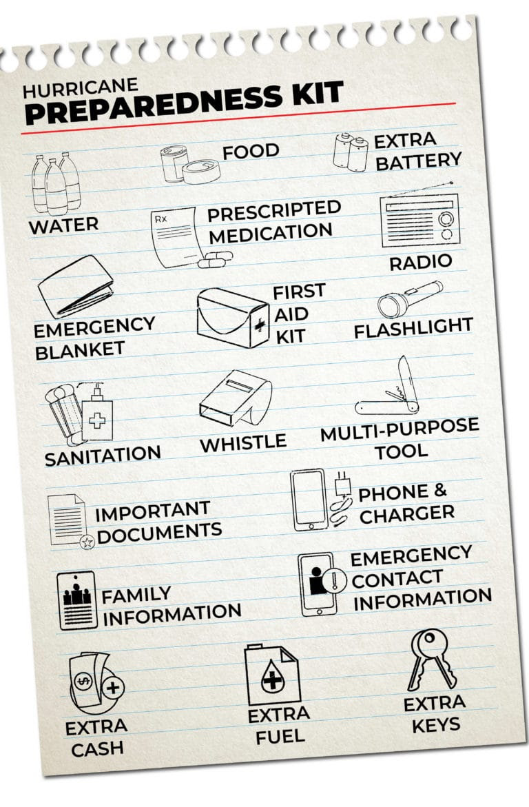
FIND YOUR LOCAL NOAA.com WEATHER RADIO STATION:
FIND YOUR LOCAL NATIONAL WEATHER SERVICE FORESCAST: 🌀 🌀 🌀 🌀 🌀 🌀 🌀 🌀 🌀 🌀 🌀 🌀 🌀 🌀

Courtesy of Cooperative Institute for Meteorological Satellite Studies (CIMSS), University of Wisconsin (All rights reserved)
INDIAN OCEAN TROPICAL CYCLONES ON .GIPHY
More on Versatileer:
![wp-17675035845798312151009952565758.jpg]()
Featured Photo: New Year's Flower of the Day '26 – Bouquet #2
01/04/2026![1235964_362441223888530_1619613803_n_.jpg]()
Featured Photo: Sunsets & Sunrises – Charles Lane and I-88, the Ronald Reagan Tollway, Aurora
01/24/2024![Teacher Tuesday September 2024-.png]()
Ends 09-23 – Teacher Tuesday - September 17th
09/17/2024![Winning Moves__Scattergories_Insert Card Here_Twistables 4x4x4__REVIEW.jpg]()
Scattergories Stackagories, Insert Card Here & Twistables 4x4x4 Puzzle from Winning Moves Games – Re...
03/08/2023![Featured Photo: Architecture, Part 1 – Churches – St. James Church-Lemont, Illinois, Part II]()
Featured Photo: Architecture, Part 1 – Churches – St. James Church-Lemont, Illinois, Part II
01/25/2021


Wow, that’s amazing! To actually see what’s going on like that, it must be similar to the view from the ISS!