My prayers are with all the families, friends and businesses in all areas!
Advisories are Still in Place!
Wait for an “all clear” status/notification to return. Please, for your own safety, always adhere to official notice! Atlantic Category 4 Hurricane Helene made a horrifying landfall last night at Perry, Florida–just east of the Aucilla River’s mouth., and is currently over the state of Kentucky, moving northward very quickly, The deadly category 4 storm is amongst the most catastrophic storms in history, and damages, power outages and deaths have also been reported outside Florida (at least 7 deaths), including Georgia (at least 11 deaths), and between Virginia including South Carolina (at least 7 deaths) and North Carolina (at least 2 deaths). It also affected Alabama, Tennessee, Kentucky, Indiana, Illinois, Missouri, and Arkansas. Helene is poised to stall further movement inland and affect southern Illinois and Missouri on Saturday the Ohio Valley and northeastern states later this weekend and possibly into next week. Helene caused significant damage to residences and commercial establishments, resulting in millions being deprived of electrical power. Damages are still not tabulated, but insurers have a rough estimate of at a minimum of $15 billion if not way more. Numerous regions continue to be subject to evacuation mandates or remain unreachable, as roadways are obstructed by water and debris, while emergency personnel endeavor to assist those affected.. Visit: The NOAA NWS National Hurricane Center’s Facebook page for more info. More technical information as provided by cdema.org – Tropical Weather Systems.

Image courtesy of NESDIS
The epic/current tropical activity report directly from NOAA NWS National Hurricane Center:
| Atlantic Category 4 Hurricane Helene 09/26/2024 – 09/27/2024 |
||||
 At Landfall: 09/26/24 at 10:58 pm EST At Landfall: 09/26/24 at 10:58 pm EST |
||||
 Current: 09/27/24 at 01:53 pm EST Current: 09/27/24 at 01:53 pm EST |
||||
|
Information Courtesy of National Hurricane Center/NOAA |
@Atlantic_Update on Twitter/”X”
Incredible pictures coming in from Clearwater of the damage from Hurricane Helene!#Helene #HurricaneHelene pic.twitter.com/oA9ND9woDd
— Hurricane Helene Updates (@Atlantic_Update) September 27, 2024
Courtesy of @Atlantic_Update on Twitter/”X”: Incredible pictures coming in from Clearwater of the…
The front of a business at approximately 9pm in Clearwater, FL.#Helene #HurricaneHelene pic.twitter.com/ITiTe2eds4
— Hurricane Helene Updates (@Atlantic_Update) September 27, 2024
Courtesy of @Atlantic_Update on Twitter/”X”: The front of a business at approximately 9pm in…
Just had a shed come flying across US 98 @VinceWaelti @RadarOmega @foxweather pic.twitter.com/4LkQCNkzpT
— Brandon Copic (@BrandonCopicWx) September 27, 2024
Courtesy of @Atlantic_Update on Twitter/”X”: Just had a shed come flying across US 98 @VinceWaelti..
Power is now OUT in #Perry #Florida as the eye wall of #Hurricane #Helene pushes in!! pic.twitter.com/lTjXUVKdQB
— Michael Koch (WGW) (@WeatherGoinWILD) September 27, 2024
Courtesy of @Atlantic_Update on Twitter/”X”: Power is now OUT in #Perry #Florida as the eye wall of…
Just like Hurricane Ian, Hurricane Helene has loads of lighting in the eye wall to offer. pic.twitter.com/7FDfxz0Ts7
— Hurricane Helene Updates (@Atlantic_Update) September 27, 2024
Courtesy of @Atlantic_Update on Twitter/”X”: Just like Hurricane Ian, Hurricane Helene has loads of…
Officially a Category 4 Major Hurricane with winds of 135mph and gusts of 155mph.
Looks to be the eye is doing another wobble to the east.
Watching closely now for landfall hotspots.#Helene #HurricaneHelene pic.twitter.com/AnEXZoOfcv
— Hurricane Helene Updates (@Atlantic_Update) September 26, 2024
Courtesy of @Atlantic_Update on Twitter/”X”: Officially a Category 4 Major Hurricane with winds of…
Please adhere to safety measures and stay out of the way of danger! Make arrangements accordingly. Current posting at – hurricanes.gov/#Helene
❖NHC OFFICIAL INFO: Official Information for Hurricane Helene ❖
[NOTES]…
Key Messages for Tropical Storm Helene Advisory 16
5:00 AM EDT Fri Sep 27, 2024
1. The storm surge along portions of the Florida Big Bend coast and other portions of the west coast of Florida should subside today.
2. Damaging wind gusts will continue to penetrate well inland over portions of Georgia and the Carolinas today, particularly over the higher terrain of the southern Appalachians. Residents in these areas should be prepared for the possibility of long-duration power outages. If you use a generator after the storm, be sure it is placed outside at least 20 feet away from doors, windows, and garages to avoid deadly carbon monoxide poisoning. Tropical Storm Helene Pote
3. Catastrophic and life-threatening flash and urban flooding, including numerous significant landslides, is expected across portions of the southern Appalachians through Friday. Considerable to locally catastrophic flash and urban flooding is likely for northwestern and northern Florida and the Southeast through Friday. Widespread significant river flooding is likely, some of which will be major to record breaking.
For the latest advisory, visit: hurricanes.gov/#Helene
En Espanol: https://www.nhc.noaa.gov/…/graphics_at4…/094338.shtml…
Pacific Tropical Report: Tropical Storm John made its second landfall on Mexico’s Pacific Coast on Thursday, reemerging after its earlier destructive journey through the country earlier in the week. John was previously a category 3 hurricane upon its original landfall. Current posting at – Tropical Storm #John
The current tropical activity report directly from the NOAA NWS National Hurricane Center:
| Pacific Extratropical Storm John 09/27/2024 |
||||
 09/27/24 at 01:37 pm PST 09/27/24 at 01:37 pm PST |
||||
|
Information Courtesy of National Hurricane Center/NOAA |
❖NHC OFFICIAL INFO: Official Information for Hurricane John

ATLANTIC CATEGORY 4 HURRICANE HELENE
🌀 🌀 🌀 🌀 🌀 🌀 🌀 🌀 🌀 🌀 🌀 🌀 🌀 🌀
See Tips: Preparedness Before, During & After Tropical Weather:
The Danger of Hurricanes & Tropical Activity ’24 – Summer & Fall Weather Series + Resources
The Danger of Floods ’24 – Spring & Summer Weather Series + Resources
The Danger of High Winds ’24 – Spring & Summer Weather Series + Resources
The Danger of Tornadoes ’24 – Spring & Summer Weather Series + Resources
Be prepared, and be safe.
🌀 🌀 🌀 🌀 🌀 🌀 🌀 🌀 🌀 🌀 🌀 🌀 🌀 🌀
MORE RESOURCES:
Versatileer WEATHER PAGE:![]() Versatileer PREPAREDNESS/COMMONSENSE TIPS & POINTERS:
Versatileer PREPAREDNESS/COMMONSENSE TIPS & POINTERS:

Tropical Activity & Wildfires Report, Tropical Systems-Atlantic & Pacific + wildfire forecasts:
![]()
Hurricane Preparedness Kit, courtesy of the Ward Law Group: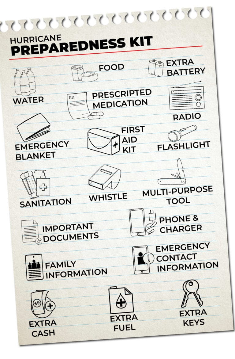
FIND YOUR LOCAL NOAA.com WEATHER RADIO STATION:
FIND YOUR LOCAL NATIONAL WEATHER SERVICE FORECAST:
ENERGY USAGE CALCULATOR: Interactive comparison tool courtesy of Energy Use Calculator: energyusecalculator.com
![]() ENERGY USAGE CALCULATOR: Interactive comparison tool courtesy of saveonenergy.com
ENERGY USAGE CALCULATOR: Interactive comparison tool courtesy of saveonenergy.com
GUIDE TO ASBESTOS & DISASTER: What to know during natural disasters![]()
STAY SAFE!!!
☀️ Current Weather
Click Blue Button
More on Versatileer:
![Quicksand box set__BUTTON.jpeg]()
Ends 07-05 – Quicksand Series Boxset by Delaney Diamond Book Blitz + $15 Amazon Gift Card + Reader’s...
06/28/2023![Cherries.jpg]()
Happy National Cherry Day – 2025
07/16/2025![20250516_183635_.jpg]()
Dust Storm Outbreak in Illinois & Indiana: 05-16-25
05/20/2025![ro-bro-SQUARE-cover copy.jpg]()
The Ro Bro by J.A. Huss & Johnathan McClain Cover Reveal – Coming on 06-20
05/21/2023![wp-17020124755395215383093325262511.jpg]()
Featured Photo + Video: The 25 Days of Christmas – Day 7: Yuletide on Birmingham Street, Chicago Rid...
12/07/2023


These are terrifying images! Lots of prayers for protection for those in the path!