My prayers are with all the families, friends and businesses in all areas!
Warnings have been activated!
Make last minute preparations, and evacuate immediately. Please, for your own safety, get out NOW!!! Atlantic Category 1 Hurricane Helene is currently in the Gulf of Mexico, springing within the last 48 hours from being a named storm to the possible landfall centered on Florida’s Big Bend of a deadly category 4 storm tomorrow, on Thursday! The future path of the storm poised for landfall in areas of the United States including Florida, Georgia, and Alabama, and extra-tropical flooding rains as it moves northward, it will affect inland states of South Carolina, North Carolina, Tennessee, Kentucky, Indiana, Illinois, Missouri, and Arkansas. This could be the most serious storm in years!! Be ready!!! This is a very serious storm, so take proper preparation now. Be ready for storm surge, high winds, power outages and possible tornadoes. Visit: The NOAA NWS National Hurricane Center’s Facebook page for more info. More technical information as provided by cdema.org – Tropical Weather Systems.
The current tropical activity report directly from the NOAA NWS National Hurricane Center:
| Atlantic Hurricane Helene – 09/25/2024 | ||||
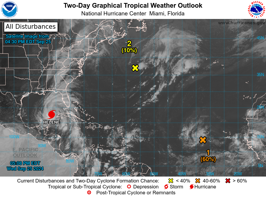 09/25/24 at 5:08 pm EST 09/25/24 at 5:08 pm EST |
||||
|
Information Courtesy of National Hurricane Center/NOAA |
 NOAA NWS National Hurricane Center on Facebook
Afternoon update on Hurricane Helene from the NHC in Miami, FL (September 25, 2024)
National Hurricane Center Deputy Director Jamie Rhome provides a LIVE update on Hurricane #Helene. As the hurricane season continues, the time to prepare is now. The Atlantic hurricane season runs until November 30.
Follow us on social media to get the latest updates! Stay tuned for posts during tropical events and LIVE updates on Facebook, YouTube, and Instagram.
Facebook & YouTube – @ NOAA/NWS National Hurricane Center
Instagram – @ nwsnhc_hurricanes
X – @ NWSNHC
For more detailed forecasts and text updates, visit Hurricanes.gov.
******************************
NOAA/National Weather Service
National Hurricane Center
Miami, FLPosted by NOAA NWS National Hurricane Center on Wednesday, September 25, 2024
Courtesy of @NWSNHC on Facebook: Afternoon update on Hurricane Helene from the NHC in…
* Here are the latest key messages for Hurricane #Helene:
Advisory 10: 4:00 PM CDT Wednesday September 25, 2024
1. A…
Posted by NOAA NWS National Hurricane Center on Wednesday, September 25, 2024
Courtesy of @NWSNHC on Facebook: * Here are the latest key messages for Hurricane #Helene…
4PM CDT Sep 25: #Helene strengthens and moves into the southeastern Gulf of Mexico. Preparations to protect life and property from storm surge and damaging winds along the Florida Big Bend Coast need to be rushed to completion today. Check back frequently for updates at… pic.twitter.com/vUhzWH4fXD
— National Hurricane Center (@NHC_Atlantic) September 25, 2024
Courtesy of @NWSNHC on Twitter/”X”: …HELENE LIKELY TO BECOME A HURRICANE TODAY…
❖NHC OFFICIAL INFO: Official Information for Hurricane Helene ❖
[NOTES]…
1. A catastrophic and deadly storm surge is likely along portions of the Florida Big Bend coast, where inundation could reach as high as 20 feet above ground level, along with destructive waves. There is also a danger of life-threatening storm surge along the remainder of the west coast of the Florida Peninsula. Residents in those areas should follow advice given by local officials and evacuate if told to do so.
2. Potentially catastrophic hurricane-force winds are expected within the eyewall of Helene when it makes landfall in the Florida Big Bend region late Thursday. Preparations to protect life and property should be completed by early Thursday before tropical storm conditions arrive. Damaging and life-threatening hurricane-force winds, especially in gusts, will penetrate well inland over portions of northern Florida and southern Georgia late Thursday and Thursday night where Hurricane Warnings are in effect. Strong wind gusts are also likely farther north across portions of northern Georgia and the Carolinas, particularly over the higher terrain of the southern Appalachians.
3. Catastrophic and life-threatening flash and urban flooding, including landslides, is expected across portions of the southern Appalachians through Friday. Considerable to locally catastrophic flash and urban flooding is likely for northwestern and northern Florida and the Southeast through Friday. Widespread minor to moderate river flooding is likely, and isolated major river flooding is possible.
4. Hurricane and tropical storm conditions are expected over northeastern portions of the Yucatan Peninsula of Mexico this evening where Tropical Storm and Hurricane Warnings are in effect. Tropical storm conditions are occurring over portions of western Cuba within the Tropical Storm Warning area, and hurricane conditions are possible this evening within the Hurricane Watch area. Helene will bring heavy rain to portions of the western Caribbean with potentially significant flooding across western Cuba and the northeastern Yucatan Peninsula into early Thursday.
For the latest advisory, visit: hurricanes.gov/#Helene
Pacific Tropical Report: Now again Tropical Storm John, after battering Mexico’s southern coast, Category 3 storm John is moving back into the Pacific Ocean after a landfall on Monday, striking Mexico’s southern Pacific coast as a Category 3 storm following a swift intensification on Monday night, according to the National Hurricane Center. In summary, the significant hurricane made landfall with maximum sustained winds reaching 120 mph, occurring just to the south-southwest of Marquelia in Guerrero state, as reported by the NHC. but is expected to hit the mainland again on Wednesday evening. The storm made landfall on Monday as a major hurricane, causing floods, landslides, and at least five deaths. It brought heavy rains to several states with major ports and beach resorts before strengthening again. The U. S. National Hurricane Center warned of potential flash floods and mudslides along Mexico’s Pacific coast. Despite initial damages, the storm is forecasted to strengthen, posing risks to communities. Scientists attribute the strengthening of hurricanes to higher sea temperatures. Current posting at – Tropical Storm #John
The current tropical activity report directly from the NOAA NWS National Hurricane Center:
| Pacific Tropical Storm John – 09/25/2024 | ||||
| 09/25/24 at 4:32 pm PST |
||||
|
Information Courtesy of National Hurricane Center/NOAA |
9/25 3pm CST Key Messages on Tropical Storm #John: Catastrophic life-threatening flash flooding currently ongoing…and expected to continue for portions of southern and southwestern #Mexico pic.twitter.com/cPjAomm6fn
— NHC Eastern Pacific (@NHC_Pacific) September 25, 2024
Courtesy of @NHC_Pacific on Twitter/”X”: 9/25 3pm CST Key Messages on Tropical Storm…
❖NHC OFFICIAL INFO: Official Information for Hurricane John ❖
[NOTES]…
[NOTES]…
1. A catastrophic and deadly storm surge is likely along portions of the Florida Big Bend coast, where inundation could reach as high as 20 feet above ground level, along with destructive waves. There is also a danger of life-threatening storm surge along the remainder of the west coast of the Florida Peninsula. Residents in those areas should follow advice given by local officials and evacuate if told to do so.
2. Potentially catastrophic hurricane-force winds are expected within the eyewall of Helene when it makes landfall in the Florida Big Bend region late Thursday. Preparations to protect life and property should be completed by early Thursday before tropical storm conditions arrive. Damaging and life-threatening hurricane-force winds, especially in gusts, will penetrate well inland over portions of northern Florida and southern Georgia late Thursday and Thursday night where Hurricane Warnings are in effect. Strong wind gusts are also likely farther north across portions of northern Georgia and the Carolinas, particularly over the higher terrain of the southern Appalachians.
3. Catastrophic and life-threatening flash and urban flooding, including landslides, is expected across portions of the southern Appalachians through Friday. Considerable to locally catastrophic flash and urban flooding is likely for northwestern and northern Florida and the Southeast through Friday. Widespread minor to moderate river flooding is likely, and isolated major river flooding is possible.
4. Hurricane and tropical storm conditions are expected over northeastern portions of the Yucatan Peninsula of Mexico this evening where Tropical Storm and Hurricane Warnings are in effect. Tropical storm conditions are occurring over portions of western Cuba within the Tropical Storm Warning area, and hurricane conditions are possible this evening within the Hurricane Watch area. Helene will bring heavy rain to portions of the western Caribbean with potentially significant flooding across western Cuba and the northeastern Yucatan Peninsula into early Thursday.
For the latest advisory, visit: Tropical Storm #John

ATLANTIC HURRICANE HELENE
🌀 🌀 🌀 🌀 🌀 🌀 🌀 🌀 🌀 🌀 🌀 🌀 🌀 🌀
See Tips: Preparedness Before, During & After Tropical Weather:
The Danger of Hurricanes & Tropical Activity ’24 – Summer & Fall Weather Series + Resources
The Danger of Floods ’24 – Spring & Summer Weather Series + Resources
The Danger of High Winds ’24 – Spring & Summer Weather Series + Resources
The Danger of Tornadoes ’24 – Spring & Summer Weather Series + Resources
Be prepared, and be safe.
🌀 🌀 🌀 🌀 🌀 🌀 🌀 🌀 🌀 🌀 🌀 🌀 🌀 🌀
MORE RESOURCES:
Versatileer WEATHER PAGE:![]() Versatileer PREPAREDNESS/COMMONSENSE TIPS & POINTERS:
Versatileer PREPAREDNESS/COMMONSENSE TIPS & POINTERS:

Tropical Activity & Wildfires Report, Tropical Systems-Atlantic & Pacific + wildfire forecasts:
![]()
Hurricane Preparedness Kit, courtesy of the Ward Law Group: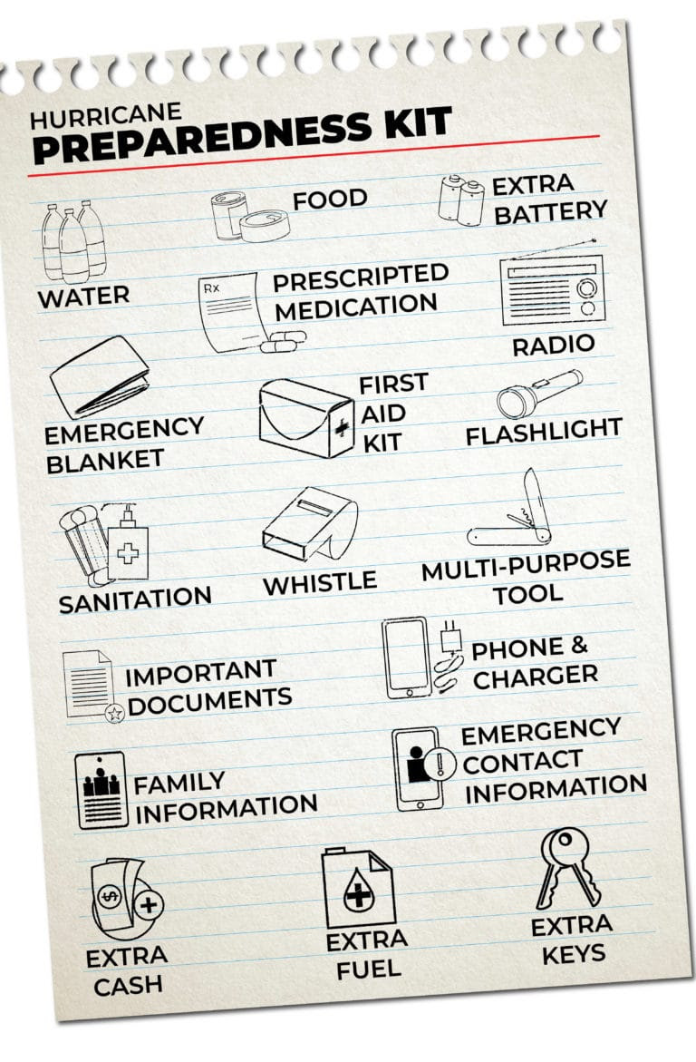
FIND YOUR LOCAL NOAA.com WEATHER RADIO STATION:
FIND YOUR LOCAL NATIONAL WEATHER SERVICE FORECAST:
ENERGY USAGE CALCULATOR: Interactive comparison tool courtesy of Energy Use Calculator: energyusecalculator.com
![]() ENERGY USAGE CALCULATOR: Interactive comparison tool courtesy of saveonenergy.com
ENERGY USAGE CALCULATOR: Interactive comparison tool courtesy of saveonenergy.com
GUIDE TO ASBESTOS & DISASTER: What to know during natural disasters![]()
STAY SAFE!!!
☀️ Current Weather
Click Blue Button
More on Versatileer:
![Soulmates and Slapshots__Melissa Release Graphics.jpg]()
Ends 10-22 – Soulmates and Slapshots by Melissa Baldwin Book Blitz + $25 Amazon Gift Card Giveaway
09/17/2025![The Price Is Right.jpg]()
Happy National Game Show Day – 2025
06/02/2025![wp-17031469310866583697746128306714.jpg]()
Featured Photo + Video: The 25 Days of Christmas – Day 20: Yuletide on Long Avenue, Oak Forest
12/21/2023![wp-16983005815235956340077789620654.jpg]()
Featured Photo & Video: The 31 Days of Halloween – Day 26: Scare on Debra Drive, Oak Forest
10/26/2023![TSOA Tropes.jpg]()
The Science of Attraction by Jay Hogan Book Blitz – Publication Date: February 22, 2024
02/23/2024


Stay safe everyone