My prayers are with all the families, friends and businesses in all areas!
Warnings have been activated!
Make last minute preparations, and evacuate immediately. Please, for your own safety, get out NOW!!! Pacific Hurricane Hilary is making it’s move to make a landfall to Florida, Georgia, South Carolina, north Carolina immediately. Remotely this storm will also affect other states on the eastern seaboard This has become a very serious storm very quickly and promises to have a very serious amount of rainfall in a short period of time, so take proper preparation now. Be ready for storm surge, high winds, power outages and possible tornadoes. Visit: The NOAA NWS National Hurricane Center’s Facebook page for more info. More technical information as provided by cdema.org – Tropical Weather Systems.
The current tropical activity report directly from the NOAA NWS National Hurricane Center:
| Atlantic Tropical Storm Debby – 08/04/2024 | ||||
 08/04/24 at 8:54 pm 08/04/24 at 8:54 pm |
||||
|
Information Courtesy of National Hurricane Center/NOAA |
 NOAA NWS National Hurricane Center on Facebook
Afternoon Update on Tropical Storm Debby from the NHC in Miami, FL (August 4, 2024)
National Hurricane Center Deputy Director Jamie Rhome provides the latest updates on Tropical Storm #Debby. As the hurricane season continues, the time to prepare is now! The Atlantic hurricane season runs until November 30.
Follow us on social media to get the latest updates! Stay tuned for posts during tropical events and LIVE updates on Facebook, YouTube, and Instagram!
Facebook & YouTube – @ NOAA/NWS National Hurricane Center
Instagram – @ nwsnhc_hurricanes
X – @ NWSNHC
For more detailed forecasts and text updates, visit hurricanes.gov.
******************************
NOAA/National Weather Service
National Hurricane Center
Miami, FLPosted by NOAA NWS National Hurricane Center on Sunday, August 4, 2024
5pm EDT Sunday #Debby Key Messages: Debby expected to strengthen to a #hurricane tonight. There is a High Risk of flash #flooding from excessive rainfall in the purple area in the lower graphic (below). Preparations to protect life & property should be rushed to completion. pic.twitter.com/9BMMA1txJj
— National Hurricane Center (@NHC_Atlantic) August 4, 2024
NHC OFFICIAL INFO: Official Information for Tropical Storm Debby ❖ PDF
[NOTES]…
Pacific Tropical Report: 2 tropical storms (Carlotta & Daniel), a tropical depression and another area with 90% chance of further development. The Pacific is getting very hot with activity right now… Residents in all areas should have a hurricane plan in action or visit https://www.weather.gov/wrn/
No flooding or other activity other than at sea expected in the Pacific.

ATLANTIC TROPICAL STORM DEBBY
🌀 🌀 🌀 🌀 🌀 🌀 🌀 🌀 🌀 🌀 🌀 🌀 🌀 🌀
See Tips: Preparedness Before, During & After Tropical Weather:
The Danger of Hurricanes & Tropical Activity ’24 – Summer & Fall Weather Series + Resources
The Danger of Floods ’24 – Spring & Summer Weather Series + Resources
The Danger of High Winds ’24 – Spring & Summer Weather Series + Resources
The Danger of Tornadoes ’24 – Spring & Summer Weather Series + Resources
Be prepared, and be safe.
🌀 🌀 🌀 🌀 🌀 🌀 🌀 🌀 🌀 🌀 🌀 🌀 🌀 🌀
MORE RESOURCES:
Versatileer WEATHER PAGE:![]() Versatileer PREPAREDNESS/COMMONSENSE TIPS & POINTERS:
Versatileer PREPAREDNESS/COMMONSENSE TIPS & POINTERS:

Tropical Activity & Wildfires Report, Tropical Systems-Atlantic & Pacific + wildfire forecasts:
![]()
Hurricane Preparedness Kit, courtesy of the Ward Law Group: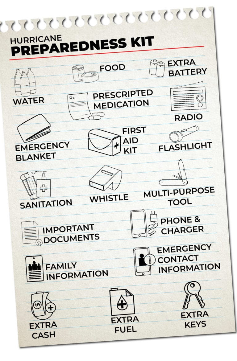
FIND YOUR LOCAL NOAA.com WEATHER RADIO STATION:
FIND YOUR LOCAL NATIONAL WEATHER SERVICE FORECAST:
ENERGY USAGE CALCULATOR: Interactive comparison tool courtesy of Energy Use Calculator: energyusecalculator.com
![]() ENERGY USAGE CALCULATOR: Interactive comparison tool courtesy of saveonenergy.com
ENERGY USAGE CALCULATOR: Interactive comparison tool courtesy of saveonenergy.com
GUIDE TO ASBESTOS & DISASTER: What to know during natural disasters![]()
STAY SAFE!!!
☀️ Current Weather
Click Blue Button
More on Versatileer:
![SMGN-FallGiftGiudeGiveaway-NatGeoPOST.png]()
Ends 10-29 – National Geographic Kids Book Bundle Giveaway!
09/24/2022![PS-coverrevealTROPES1.jpeg]()
Petulant Shadows by Martha Sweeney Cover Reveal – Release Date Coming October 17th
08/16/2023![INSTA_AvengeMe.png]()
Ends 01-15 – Avenge Me by Tamela Miles Book Blitz + $15 Amazon Gift Card Giveaway
01/03/2025![Meta tools.webp]()
Happy National Worship of Tools Day – 2024
03/11/2024![close-up-photo-of-person-lying-beside-a-syringe-and-tablets-11030157 overdose_1693634406.jpeg Towfiqu barbhuiya at Pexels]()
International Overdose Awareness Day + Treatment Resources
09/02/2023


I live in MYRTLE BEACH SOUTH CAROLINA
Be safe everyone
No matter the fact these storms come yearly, it never makes them less scary!