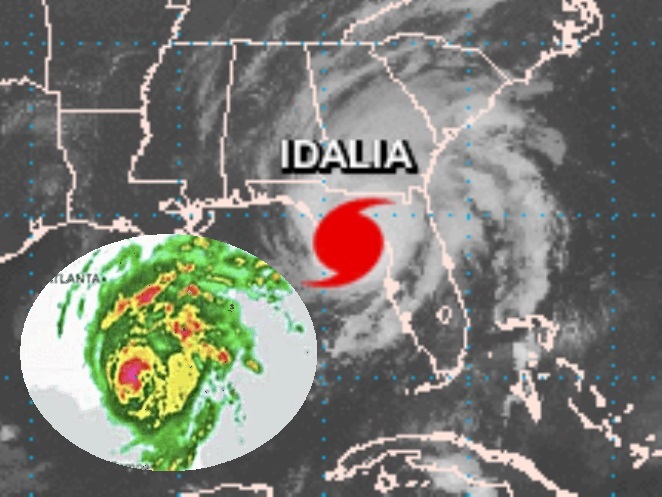
Because of the beauty from the eye in the sky. . .I am featuring a .GIF of the whole loop of Atlantic Category 4 Hurricane Idalia, which moved directly over the land areas of Florida, Georgia, South Carolina and North Carolina, and also affected many more states including Virginia. Idalia started in the far eastern Pacific Ocean at 12°N & 89°W just south of El Salvador and moved northward directly over the 3 country region area of El Salvador, Honduras and Nicaragua, and moving into the Carribean northward where it meandered slowly in a static move. Idalia continued as a disturbance northward looking like it would enter the Gulf and then trekked down south back into the warm Caribbean, being upgraded to Depression 10 and then tropical storm and being named–and then Idalia started moving north once again into the Gulf quickly becoming a hurricane and then a completely dangerous category 4 storm before moving ashore on August 30th in Florida near Steinhatchee and Perry. Idalia turned right and continued north- northeastward as a hurricane completely over inland Florida and didn’t lose enough strength to be downgraded to a tropical storm nealy until it was over Georgia. On it’s northeast move Idalia continued as a tropical storm clearly through South Carolina and North Carolina and then eastward over the Atlantic before quickly fizzling but staying together enough to make it hundreds of miles as a dissolving storm, finally fizzling at 32°N & 67°W, as featured all on one loop, on .GIPHY:
See Video on YouTube:
Atlantic Hurricane Name Chart:
| 2023 Atlantic Hurricane Names (in Order) | |||
| LETTER | NAME/LINK/PRONOUNCED | Versatileer Post |
IMAGE |
| ● | 01/16/23 Pre-Season Activity | January Disturbance |  |
| A | Arlene (ar-LEEN) |
Arlene | |
| B |
Bret (bret) |
Bret |  |
| C |
Cindy (SIN-dee) | Cindy |  |
| D |
Don (dahn) |
Don |  |
| E |
Emily (EH-mih-lee) |
Emily |  |
| F |
Franklin (FRANK-lin) |
Franklin |  |
| G |
Gert (gert) |
Gert |  |
| H |
Harold (HAIR-uld) |
Harold |  |
| I |
Idalia (ee-DAL-ya) |
CURRENT .gif | 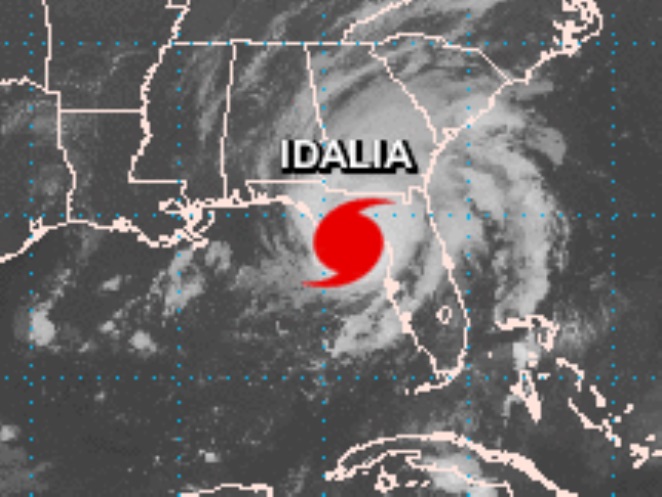 |
| J |
Jose (ho-ZAY) |
— |
— |
| K |
Katia (KAH-tyah) |
— |
— |
| L |
Lee (lee) |
— |
— |
| M |
Margot (MAR-go) |
— |
— |
| N |
Nigel (NY-juhl) |
— |
— |
| O |
Ophelia (o-FEEL-ya) |
— |
— |
| P |
Philippe (fee-LEEP) |
— |
— |
| R |
Rina (REE-nuh) |
— |
— |
| S |
Sean (shawn) |
— |
— |
| T |
Tammy (TAM-ee) |
— |
— |
| V |
Vince (vinss) |
— |
— |
| W |
Whitney (WHIT-nee) |
— |
— |
Idalia GOES East Feed courtesy NOAA.com
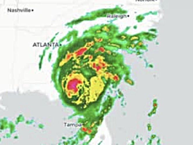
Idalia Radar Loop courtesy of openweathermap.org
🌀 🌀 🌀 🌀 🌀 🌀 🌀 🌀 🌀 🌀 🌀 🌀 🌀
Atlantic Tropical Storm Idalia – Make Preparations Accordingly for Landfall Tomorrow to Wednesday!
See Tips: Preparedness Before, During & After Tropical Weather:
The Danger of Hurricanes & Tropical Activity ’23 – Summer & Fall Weather Series + Resources https://t.co/eO7RFVuyS4 via @Versatileer
— Jerry Marquardt (@Versatileer) June 1, 2023
Click here if Twitter widget does not show
ATLANTIC CATEGORY 4 HURRICANE IDALIA
MORE RESOURCES:
Versatileer WEATHER PAGE:![]() Versatileer PREPAREDNESS/COMMONSENSE TIPS & POINTERS:
Versatileer PREPAREDNESS/COMMONSENSE TIPS & POINTERS:

Tropical Activity & Wildfires Report, Tropical Systems-Atlantic & Pacific + wildfire forecasts:
![]()
Hurricane Preparedness Kit, courtesy of the Ward Law Group: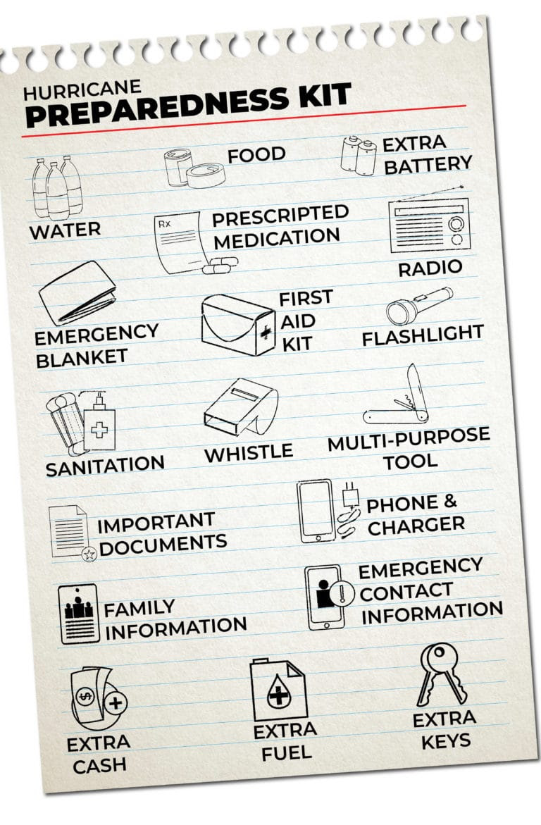
FIND YOUR LOCAL NOAA.com WEATHER RADIO STATION:
FIND YOUR LOCAL NATIONAL WEATHER SERVICE FORECAST:
ENERGY USAGE CALCULATOR: Interactive comparison tool courtesy of Energy Use Calculator: energyusecalculator.com
![]() ENERGY USAGE CALCULATOR: Interactive comparison tool courtesy of saveonenergy.com
ENERGY USAGE CALCULATOR: Interactive comparison tool courtesy of saveonenergy.com GUIDE TO ASBESTOS & DISASTER: What to know during natural disasters
![]()
Be prepared, and be safe.
More on Versatileer:
![Winning-Photos-Nature-Photography-Day-2024-25-Giveaway.jpg]()
Ends 09-17 – Winning Photos: Nature Photography Day – 2024 + $25 Giveaway
06/16/2024![black handled knife on blue textilejpg]()
Happy National Muffin Day – 2025
02/20/2025![wp-17312071373441419188167073090497.jpg]()
Featured Photo: The Beauty of Fall Color – Elm Trees
11/10/2024![Babe in the Woods Blitz__BUTTON.jpg]()
Ends 06-14 – Babe in the Woods by Jude Hopkins Book Blitz + $25 Amazon Gift Card Giveaway
06/07/2023![cheesecake, cake, dessert, sweets, food, chocolate, syrup, plate, brown cake, brown candy, brown dessert, brown chocolate, cheesecake, cheesecake, cheesecake, cheesecake, cheesecake.jpg]()
Happy National White Chocolate Cheesecake Day – 2025
03/06/2025