Because of the beauty from the eye in the sky. . .I am featuring a .GIF of the whole loop of Pacific Hurricane Calvin, which remained over water for the whole duration, starting out in the waters way under the Mexico-Guatemala border at 8°N & 92°W, migrating mostly westward and turning into a hurricane at 13°N & 117°W, migrating further, going into the central satellite zone, to finally make it to just below Hawaii at 18°N & 158°W before fizzling. Calvin only migrated 10°N, but made it a whopping 66°W on its whole path, which is over one-sixth of the span of the Earth, and is featured all on one loop, on .GIPHY:
See Video on YouTube:
Pacific Hurricane Name Chart:
| 2023 Pacific Hurricane Names (in Order) | |||
| LETTER | NAME/LINK/PRONOUNCED | Versatileer Post |
IMAGE |
| A | Adrian (AY-dree-uhn) |
Adrian |  |
| B |
Beatriz (BEE-a-triz) |
Beatriz |  |
| C |
Calvin (KAL-vin) |
CURRENT .gif | 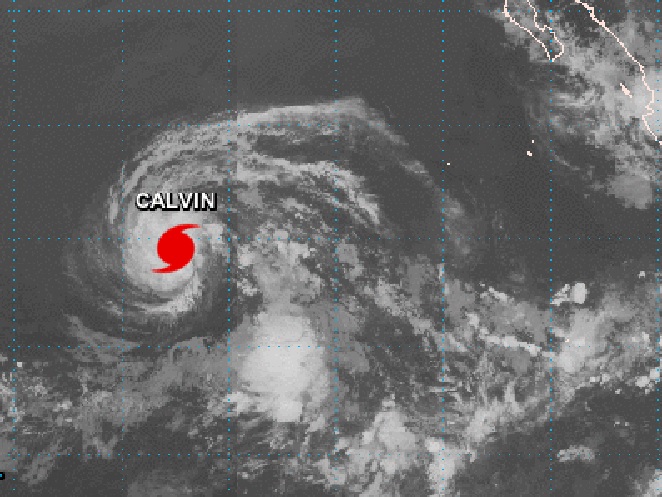 |
| D |
Dora (DOR-ruh) |
— |
— |
| E |
Eugene (YOU-jeen) |
— |
— |
| F |
Fernanda (fer-NAN-dah) |
— |
— |
| G |
Greg (greg) |
— |
— |
| H |
Hilary (HIH-luh-ree) |
— |
— |
| I |
Irwin (UR-win) |
— |
— |
| J |
Jova (HO-vah) |
— |
— |
| K |
Kenneth (KEH-neth) |
— |
— |
| L |
Lidia (LIH-dyah) |
— |
— |
| M |
Max (maks) |
— |
— |
| N |
Norma (NOOR-muh) |
— |
— |
| O |
Otis (OH-tis) |
— |
— |
| P |
Pilar (Pee-LAHR) |
— |
— |
| R |
Ramon (rah-MOHN) |
— |
— |
| S |
Selma (SELL-mah) |
— |
— |
| T |
Todd (tahd) |
— |
— |
| V |
Veronica (vur-RAHN-ih-kuh) |
— |
— |
| W |
Wiley (WY-lee) |
— |
— |
| X |
Xina (ZEE-nah) |
— |
— |
| Y |
York (york) |
— |
— |
| Z |
Zelda (ZEL-dah) |
— |
— |
🌀 🌀 🌀 🌀 🌀 🌀 🌀 🌀 🌀 🌀 🌀 🌀 🌀
See Tips: Preparedness Before, During & After Tropical Weather:
The Danger of Hurricanes & Tropical Activity ’23 – Summer & Fall Weather Series + Resources https://t.co/eO7RFVuyS4 via @Versatileer
— Jerry Marquardt (@Versatileer) June 1, 2023
Click here if Twitter widget does not show
PACIFIC HURRICANE CALVIN
MORE RESOURCES:
Versatileer WEATHER PAGE:![]() Versatileer PREPAREDNESS/COMMONSENSE TIPS & POINTERS:
Versatileer PREPAREDNESS/COMMONSENSE TIPS & POINTERS:

Tropical Activity & Wildfires Report, Tropical Systems-Atlantic & Pacific + wildfire forecasts:
![]()
Hurricane Preparedness Kit, courtesy of the Ward Law Group: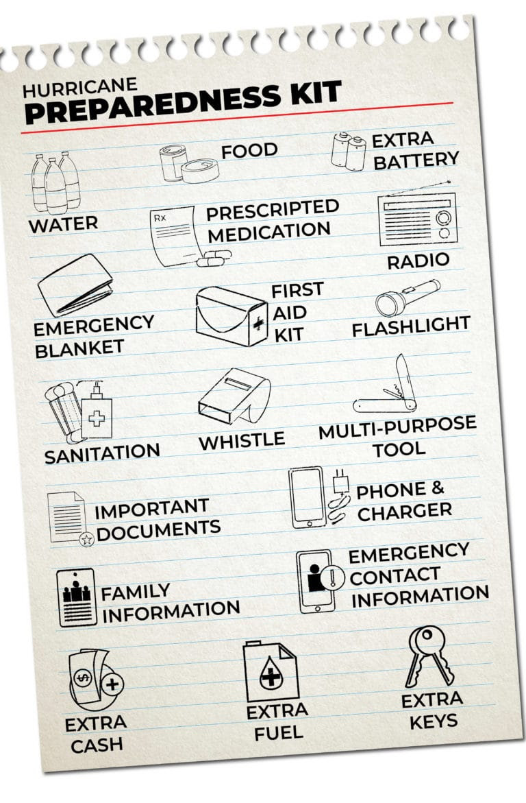
FIND YOUR LOCAL NOAA.com WEATHER RADIO STATION:
FIND YOUR LOCAL NATIONAL WEATHER SERVICE FORECAST:
ENERGY USAGE CALCULATOR: Interactive comparison tool courtesy of Energy Use Calculator: energyusecalculator.com
![]() ENERGY USAGE CALCULATOR: Interactive comparison tool courtesy of saveonenergy.com
ENERGY USAGE CALCULATOR: Interactive comparison tool courtesy of saveonenergy.com GUIDE TO ASBESTOS & DISASTER: What to know during natural disasters
![]()
Be prepared, and be safe.
More on Versatileer:
![Stand Up for Religious Freedom.jpg]()
Happy National Religious Freedom Day – 2026
01/21/2026![RoyallyOffLimits__8.jpg]()
Ends 11-12 – Royally Off-Limits by Kate O’Keeffe Book Blitz + $25 Amazon Gift Card Giveaway
11/05/2025![woman in white button up shirt and blue stethoscope.jpg]()
Happy National Emergency Nurse Day & Emergency Nurses Week - 2024
10/10/2024![20221212_1326525383051940758351764.jpg]()
Featured Photo: Christmas Flower of the Day – Bouquet #4
12/19/2022![selective-focus-photo-of-cannabis-plant-7667839 marijuana_1650503625.jpeg Kindel Media at Pexels]()
Safety & Cannabis Use, 420 Day + Treatment Resources
04/20/2022