


My prayers are with all the families, friends and businesses in all areas!
Warnings have been activated!
The dangerous Santa Ana winds!! The wildfires are roaring in with wind speeds over hurricane speeds, at over 75 miles per hour in Palisades and Los Angeles County. Visit: Palisades Fire: Incident Update on 01/09/2025 at 5:37 PM | CAL FIRE for more info.


Video Courtesy of CAL FIRE_Official | Flickr
🔥 🔥 🔥
More technical information as provided by earthobservatory.nasa.gov:

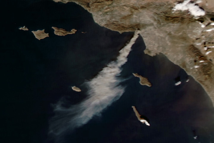
Image Courtesy of earthobservatory.nasa.gov
🔥 🔥 🔥
See the Fire Weather Zone Maps from the Weather Forecast Office provided by the Weather.gov | Los Angeles, CA:


Image Courtesy of Weather.gov
🔥 🔥 🔥
See the Significant Wildland Fire Potential Outlook Maps from the Weather Forecast Office provided by the National Interagency Coordination Center:


Image Courtesy of National Interagency Coordination Center
🔥 🔥 🔥 🔥 🔥 🔥 🔥 🔥 🔥 🔥 🔥 🔥 🔥 🔥
See Video on YouTube:

CALIFORNIA WILDFIRES
🔥 🔥 🔥 🔥 🔥 🔥 🔥 🔥 🔥 🔥 🔥 🔥 🔥 🔥
See Tips: Preparedness Before, During & After Wildfires:
The Danger of Wildfires ’24 – Summer & Fall Weather Series + Resources
Be prepared, and be safe.
🔥 🔥 🔥 🔥 🔥 🔥 🔥 🔥 🔥 🔥 🔥 🔥 🔥 🔥

❤️ ❤️ ❤️ ❤️ ❤️ ❤️ ❤️ ❤️ ❤️ ❤️ ❤️ ❤️ ❤️ ❤️ ❤️
See Versatileer‘s article in regards to Donate With Maximum Donation Going To Cause…Steering Clear of the Lofty Perch for more information.
RESOURCES:
🔥 CURRENT WILDFIRE MAP: 🔥


MORE RESOURCES:
Versatileer WEATHER PAGE:![]()


Tropical Activity & Wildfires Report, Tropical Systems-Atlantic & Pacific + wildfire forecasts:
![]()


FIND YOUR LOCAL NATIONAL WEATHER SERVICE FORECAST:
ENERGY USAGE CALCULATOR: Interactive comparison tool courtesy of Energy Use Calculator: energyusecalculator.com
![]()


GUIDE TO ASBESTOS & DISASTER: What to know during natural disasters![]()

STAY SAFE!!!
