|
36 Tornado Outbreak (At Least) – 03/31/2023
Iowa, Illinois & Indiana
|
|
Tornadoes #1 to #24 + MORE (Reports not final)
Illinois to Indiana
|
|
Near Amboy, IL
|
EF-2
|
|
West Brooklyn, IL
|
EF-1
|
|
Near Baileyville, IL
|
TBD
|
|
Machesney Park, IL
|
EF-1
|
|
Davis Junction-Belvidere, IL
|
EF-1
|
|
Caledonia/Poplar Grove, IL
|
TBD
|
|
Montgomery, IL & Aurora, IL
|
EF-0
|
|
Plainfield, IL
|
EF-0
|
|
Near Wellington, IL
|
EF-1
|
|
Near Stockland, IL
|
EF-1
|
|
Lombard to Addison, IL
|
EF-1
|
|
Near Oxford, IN
|
EF-2
|
|
Near Fowler, IN
|
EF-2
|
|
Near Remington, IN
|
EF-1
|
|
Merrillville and Valparaiso
|
TBD
|
|
Batavia, Frankfort-Park Forest & Minooka-Channahon
|
TBD
|
|
Near Banner, IL
|
TBD
|
|
Chapin, IL
|
TBD
|
|
Sherman, IL
|
EF-2
|
|
Riverton, IL
|
EF-2 |
|
Morrisonville, IL
|
EF-0
|
|
Rantoul, IL
|
EF-1
|
|
Robinson, IL
|
EF-3 |
|
Rankin, IL
|
EF-1
|
|
Summary:
Fatalities are still being tabulated. Damages are still being accessed. There is at least one major incidence of fatality and major damage in the Belvidere touchdown in at the Apollo Theater in Belvidere, Illinois. In the end, there were at the very least 16 tornadoes of which 4 tornadoes are still being accessed for the EF rating.
.GIF Image Video
|
|
|
|
|
|
|
|
|
Tornado #25 – Bennett, IA
Cedar County IA
|
|
Date
|
03/31/2023
|
|
Time (Local)
|
05:18 PM- 05:41 PM
|
|
EF Rating
|
EF-2
|
|
Est. PeakWinds
|
120 mph
|
|
Path Length
|
19.6 miles
|
|
Max Width
|
200 yards
|
|
Injuries/Deaths
|
2 / 0
|
|
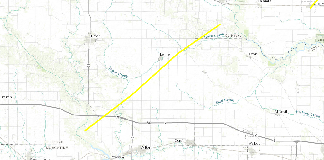
Summary:
An EF-2 tornado touched down 3 miles north of Atalissa, Iowa snapping power poles and large trees along its path. It caused significant damage to two homes southwest of Bennett, Iowa and flipped over a semi along interstate 80. It also damaged several concrete block silos south of Bennett. The tornado continued to track to the northeast through a rural area, causing sporadic tree damage before dissipating approximately 8 miles northeast of Bennett. Times were estimated from radar.
Track Map
|
|
|
|
|
Tornado #26 – Bennett, IA
Cedar County IA – Clinton County IA
|
|
Date
|
03/31/2023
|
|
Time (Local)
|
05:50 PM – 06:15 PM
|
|
EF Rating
|
EF-2
|
|
Est. Peak Winds
|
120 mph
|
|
Path Length
|
17.5 miles
|
|
Max Width
|
350 yards
|
|
Injuries/Deaths
|
1 / 0
|
|
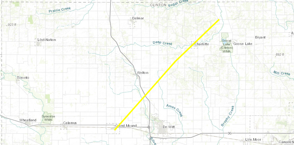
Summary:
Strong tornado developed over the southeast parts of grand mound, Iowa, and tracked through charlotte, Iowa. A continuous damage track was noted, with several damaged houses, especially in charlotte. Highest damage rating was located northeast of grand mound, where a whole house was shifted off of its foundation, where the house also completely collapsed. Many areas noted tree damage and snapped power poles along the track of the tornado as well. A lot of damage was also noted in Charlotte, associated with partial to complete damage to barns and outbuildings. 3 people were trapped in the house that collapsed in grand mound, with one that was transported to the hospital with minor injuries.
Track Map
|
|
|
|
|
Tornado #27 – Bellevue, IA
Jackson County IA – Jo Daviess County IL
|
|
Date
|
03/31/2023
|
|
Time (Local)
|
06:16 PM – 06:24 PM
|
|
EF Rating
|
EF-1
|
|
Est. Peak Winds
|
105 mph
|
|
Path Length
|
5.5 miles
|
|
Max Width
|
100 yards
|
|
Injuries/Deaths
|
3 / 0
|
|
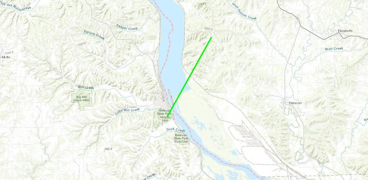
Summary:
Brief touchdown just south of Bellevue, tracking northeast across the Mississippi river. This tornado impacted an RV park and some cabins located nearby. Some structural damage was noted, with some RVs that were flipped and damaged. Several trees within the area were also impacted, with some uprooted. 3 injuries were noted with this tornado.
Track Map
|
|
|
|
|
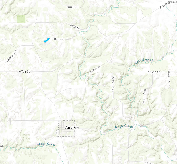
Tornado #28 – Andrew, IA
Jackson County, IA
|
|
Date
|
03/31/2023
|
|
Time (Local)
|
06:09 PM – 06:10 PM
|
|
EF Rating
|
EF-0
|
|
Est. Peak Winds
|
74 mph
|
|
Path Length
|
0.1 mile
|
|
Max Width
|
15 yards
|
|
Injuries/Deaths
|
0 / 0
|
|
Summary:
A shed roof and walls were destroyed and blown in a narrow path to 184th street where a narrow path of tree damage occurred. Surrounding the path of shed and trees were undamaged areas.
Track Map
|
|
|
|
|
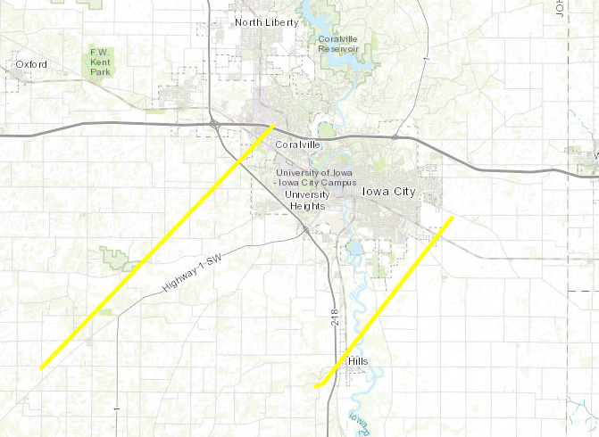
Tornado #29 – Coralville, IA
Johnson County, IA
|
|
Date
|
03/31/2023
|
|
Time (Local)
|
04:42 PM – 04:57 PM
|
|
EF Rating
|
EF-2
|
|
Est. Peak Winds
|
120 mph
|
|
Path Length
|
75 yards
|
|
Max Width
|
75 yards
|
|
Injuries/Deaths
|
2 / 0
|
|
Summary:
A tornado moved northeast destroying trees, a few outbuildings, and a grain bin in rural Johnson County. Then the tornado crossed Hwy 218 heavily damaging the James St Warehouse near Hwy 6 in Coralville. Several trailers and a truck were flipped over in vicinity. A retail building also had part of a roof lifted off with several vehicles rolled or flipped. The tornado then tracked into a residential area destroying many trees that became uprooted and snapped. At least 2 injuries were reported by emergency management at this time. The tornado then dissipated before reaching interstate 80.
Track Map
|
|
|
|
|
Tornado #30 – Hills, IA
Johnson County, IA
|
|
Date
|
03/31/2023
|
|
Time (Local)
|
04:53 PM – 05:02 PM
|
|
EF Rating
|
EF-2
|
|
Est. Peak Winds
|
120 mph
|
|
Path Length
|
8.8 miles
|
|
Max Width
|
50 yards
|
|
Injuries/Deaths
|
0 / 0
|
|
Summary:
A tornado began southwest of hills moving northeast crossing Hwy 218 through the northwest portions of town, destroying several outbuildings, large trees, and trim/siding on houses. The greatest damage was seen in western portions of the town of hills where roofs were completely torn off, siding removed from several homes and a large outbuilding destroyed. The tornado then proceeded through a wooded area with several trees snapped. It then continued northeast destroying siding and roofs on several homes on the extreme southeast side of Iowa City before dissipating just past the railroad tracks northeast of Hwy 6.
Track Map
|
|
|
|
|
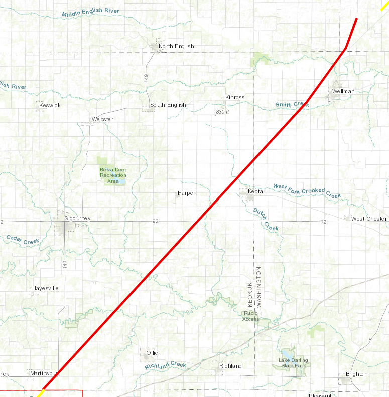
Tornado #31 – Keota, IA
Keokuk County – Washington County, Johnson County IA
|
|
Date
|
03/31/2023
|
|
Time (Local)
|
03:48 PM – 4:37 PM
|
|
EF Rating
|
EF-4
|
|
Est. Peak Winds
|
170 mph
|
|
Path Length
|
Unknown
|
|
Max Width
|
600 yards
|
|
Injuries/Deaths
|
3 / 0
|
|
Summary:
A large violent tornado developed in southern Keokuk County and tracked to the northeast across mostly open farmland through eastern Keokuk County, northwest Washington county, into far southwest Johnson County. The tornado produced EF-3 damage to a house northeast of Martinsburg, Iowa. It severely damaged several homes near Keota, wiping one house completely off its foundation, resulting in EF-4 level damage. A car was lofted in the air and tossed about 1000 feet into a nearby field and trees were completely debarked with only stubs of the largest branches remaining. As the tornado tracked west of Wellman, Iowa it knocked over a 325 ft cell phone tower. The tornado began to dissipate as it tracked into far southwest Johnson County. We are Still in the process of gathering information on this tornado track and plan to update with additional details over the coming days.
Track Map
|
|
|
|
|
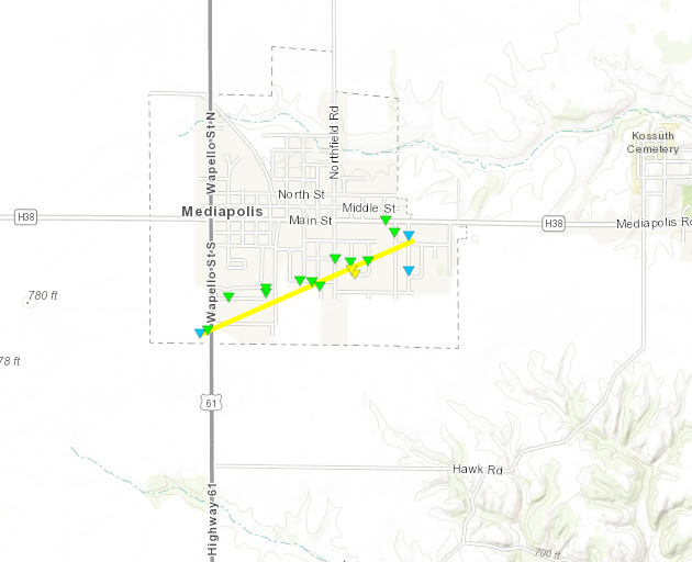
Tornado #32 -Mediapolis, IA
Des Moines County IA
|
|
Date
|
03/31/2023
|
|
Time (Local)
|
05:41 PM – 05:43 PM
|
|
EF Rating
|
EF-2
|
|
Est. Peak Winds
|
120 mph
|
|
Path Length
|
1.0 mile
|
|
Max Width
|
150 yards
|
|
Injuries/Deaths
|
0 / 0
|
|
Summary:
A brief tornado tracked east across the southern portions of the town of Mediapolis destroying siding and shingles on a few homes and businesses. Several large tree limbs fell on mobile homes damaging roofs and siding. The tornado dissipated quickly on the east side of town.
Track Map
|
|
|
|
|
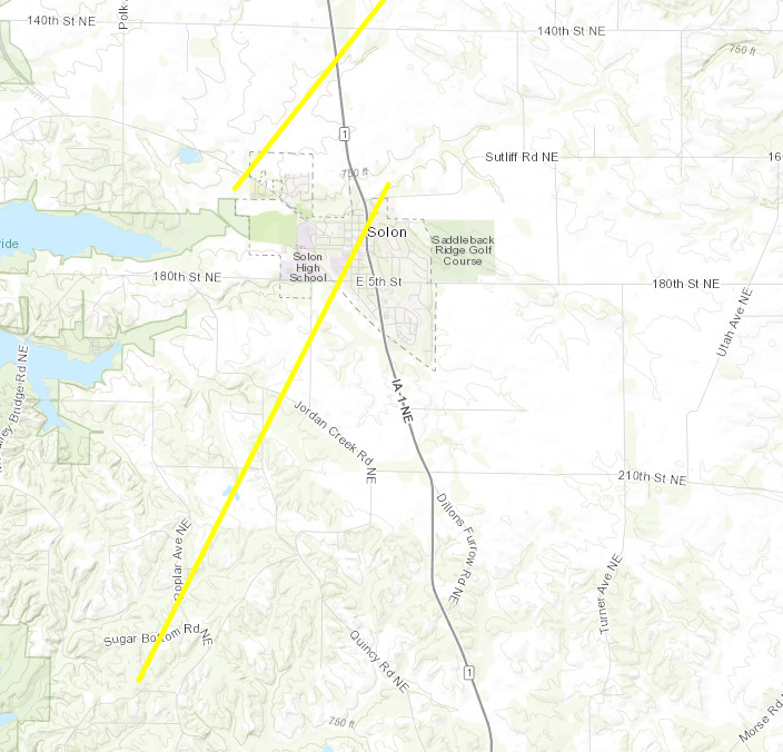
Tornado #33 – SW Solon, IA
Johnson County, IA
|
|
Date
|
03/31/2023
|
|
Time (Local)
|
05:09 PM – 05:14 PM
|
|
EF Rating
|
EF-2
|
|
Est. Peak Winds
|
125 mph
|
|
Path Length
|
4.4 miles
|
|
Max Width
|
50 yards
|
|
Injuries/Deaths
|
0 / 0
|
|
Summary:
A tornado began east of the Sugar Bottom campground east of North Liberty tracking northeast towards Solon. A radio tower collapses early in the track with several tree branches down as well near the tower. A roof was lifted off of a home and partially removed northeast of the tower. The tornado continued northeast into a field before eventually reaching another farmstead and destroying an outbuilding. Debris from the farmstead was lofted into a field with a 2×4 driven into the ground. The tornado continued into Solon uprooting trees, bending street signs, and destroying another outbuilding before dissipating and lifting just north of Sutliff Rd.
Track Map
|
|
|
|
|
Tornado #34 – 1 WNW Solon IA
Johnson County – Linn County IA
|
|
Date
|
03/31/2023
|
|
Time (Local)
|
05:06 PM – 05:17 PM
|
|
EF Rating
|
EF-2
|
|
Est. Peak Winds
|
130 mph
|
|
Path Length
|
8.0 miles
|
|
Max Width
|
75 yards
|
|
Injuries/Deaths
|
0 / 0
|
|
Summary:
A tornado developed just northwest of Solon and moved northeast destroying and snapping several trees and a small portion of a shed roof. A farmstead north of Solon lost 2 large outbuildings and grain silos. Power poles were also snapped in a field. As the tornado neared the Johnson-Linn county line, many trees were snapped or uprooted with a few rolling through the part of the adjacent field. A house sustained minor shingle damage and broken windows. The tornado continued and did some roof damage to another house and outbuilding before dissipating shortly thereafter.
Track Map
|
|
|
|
|
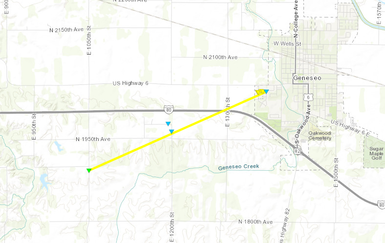
Tornado #35 – Geneseo, IL
Henry County IL
|
|
Date
|
03/31/2023
|
|
Time (Local)
|
06:24 PM – 06:31 PM
|
|
EF Rating
|
EF-2
|
|
Est. Peak Winds
|
135 mph
|
|
Path Length
|
3.6 miles
|
|
Max Width
|
300 yards
|
|
Injuries/Deaths
|
0 / 0
|
|
Summary:
Strong tornado developed a few miles southwest of Geneseo, IL and tracked into the west side of town. Ground scouring was noted in the path through the fields, heading towards town. In town, several structures were damaged to completely destroyed including: farms, businesses, and warehouses. Several vehicles and trees were also damaged in the path of the tornado.
Track Map
|
|
|
|
|
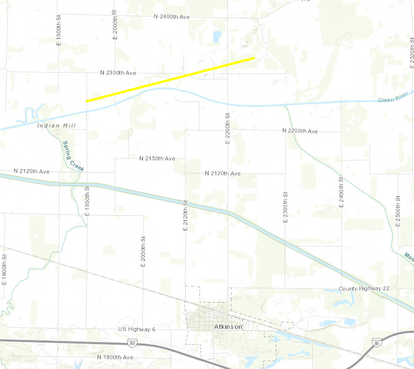
Tornado #36 -4 N Atkinson IL
Henry County IL
|
|
Date
|
03/31/2023
|
|
Time (Local)
|
06:33 PM – 06:37 PM
|
|
EF Rating
|
EF-2
|
|
Est. Peak Winds
|
110 mph
|
|
Path Length
|
3.1 miles
|
|
Max Width
|
200 yards
|
|
Injuries/Deaths
|
0 / 0
|
|
Summary:
Brief, yet strong tornado tracked north of Atkinson, IL for a few miles, leading to tree damage and damage to farmsteads. Total destruction was noted on one of the outbuildings, with debris scattered throughout the nearby fields.
Track Map
|
|
|
|


 Featured Photo: The 24 Hours of Halloween – Hour of 2 am: Dead End Cemetery on Kilpatrick10/31/2022
 Photo of the Day: 11/07/19 – Off of Ventura Freeway, California11/07/2019
 Photo of the Day: 9/5/1909/05/2019
 Featured Photo: Christmas Flower of the Day '23 – Bouquet #812/16/2023
 Happy Fourth of July!07/04/2019