
My prayers are with all the families, friends and businesses in both regions!
🌀🌀🌀🌀🌀🌀🌀🌀🌀🌀🌀🌀🌀🌀🌀🌀🌀🌀🌀🌀🌀🌀🌀🌀🌀🌀🌀🌀🌀🌀🌀🌀🌀🌀🌀🌀
The wrath of the storm is coming in right now! My prayers….
More technical information as provided by cdema.org – Tropical Weather Systems.
Current tropical activity report directly from the NOAA NWS National Hurricane Center:
↓ At 12:19 pm ↓

🌀🌀🌀🌀🌀🌀🌀🌀🌀🌀🌀🌀🌀🌀🌀🌀🌀🌀🌀🌀🌀🌀🌀🌀🌀🌀🌀🌀🌀🌀🌀🌀🌀🌀🌀🌀
Sally: Check out for your local listings here: Nationwide Station Listing Using Broadcast Frequencies. Please read the emergency post. Have an escape plan. All residents along the Gulf Coast should have a hurricane plan in action or visit https://www.weather.gov/wrn/hurricane-preparedness. Please adhere to safety measures and stay out of the way of danger! Current posting from the NOAA NWS National Hurricane Center:
…SALLY MEANDERING OVER THE NORTH-CENTRAL GULF OF MEXICO…
…EXPECTED TO RESUME A SLOW WEST-NORTHWESTWARD MOTION.
*** A Storm Surge Warning is in effect for…
* Port Fourchon Louisiana to the Alabama/Florida State Line
* Lake Pontchartrain, Lake Maurepas, Lake Borgne and Mobile Bay
*** A Hurricane Warning is in effect for…
* Morgan City Louisiana to the Alabama/Florida State Liner
* Lake Pontchartrain and Lake Maurepas incl. metropolitan NewOrleans
*** A Tropical Storm Warning is in effect for…
* Alabama/Florida State Liner to Indian Pass Florida
* Intracoastal City Louisiana to west of Morgan City
*** A Tropical Storm Watch is in effect for…
* Indian Pass to Ochlockonee River Florida
Hurricane conditions are expected to begin within the hurricane warning area tonight. Tropical storm conditions are possible within the watch area today, and are expected to begin within the warning area later today. Preparations to protect life and property should be rushed to completion. For storm information specific to your area, including possible inland watches and warnings, please monitor products issued by your local National Weather Service forecast office – www.weather.gov
A tornado or two may occur this afternoon through Tuesday over coastal areas of the Florida Panhandle, Mississippi, Alabama, and extreme southeastern Louisiana.
At 1 p.m. CDT, the center of Hurricane Sally was located about 125 miles (200 km) east-southeast of the mouth of the Mississippi River and about 160 miles (260 km) southeast of Biloxi, Mississippi. Sally has been meandering over the north-central Gulf of Mexico today, but a west-northwest near 7 mph (11 km/h) should resume later today. A decrease in forward speed and a turn toward the northwest is forecast tonight and a northward turn is expected sometime on Tuesday. On the forecast track, the center of Sally will move over the north-central Gulf of Mexico today, approach southeastern Louisiana tonight, and make landfall in the hurricane warning area on Tuesday or Tuesday night. Afterward, Sally is expected to move slowly north-northeastward near the northern Gulf Coast through Wednesday.
Maximum sustained winds are near 90 mph (150 km/h) with higher gusts a category 1 hurricane on the Saffir-Simpson Hurricane Wind Scale. Hurricane-force winds extend outward up to 25 miles (35 km) from the center and tropical-storm-force winds extend outward up to 125 miles (205 km). Additional strengthening is forecast to take place during the next day or so, and Sally is expected to be a dangerous hurricane when it moves onshore along the north-central Gulf coast.
The combination of a dangerous storm surge and the tide will cause normally dry areas near the coast to be flooded by rising waters moving inland from the shoreline. The water could reach the following heights above ground somewhere in the indicated areas if the peak surge occurs at the time of high tide…
– Mouth of the Mississippi River to Ocean Springs, MS including Lake Borgne…7-11 ft
– Ocean Springs, MS to MS/AL Border…5-8 ft
– MS/AL Border to AL/FL Border including Mobile Bay…4-7 ft
– Lake Pontchartrain and Lake Maurepas…4-6 ft
– Port Fourchon, LA to Mouth of the Mississippi River…3-5 ft
AL/FL Border to Chassahowitzka, FL including Pensacola Bay, Choctawhatchee Bay, and Saint Andrew Bay…1-3 ft
– Burns Point, LA to Port Fourchon, LA…1-3 ft
Overtopping of local levees outside of the Hurricane and Storm Damage Risk Reduction System is possible where local inundation values may be higher than those shown above.
Sally is expected to be a slow moving system as it approaches land, producing 8 to 16 inches of rainfall with isolated amounts of 24 inches over portions of the central Gulf Coast from the western Florida Panhandle to far southeast Louisiana through the middle of the week. Life-threatening flash flooding is likely. In addition, this rainfall will likely lead to widespread minor to isolated major flooding on area rivers.
The next complete advisory will be issued by NHC at 4 p.m. CDT – www.hurricanes.gov
…PAULETTE STRENGTHENING WHILE MOVING AWAY FROM BERMUDA…
…TROPICAL STORM CONDITIONS AND RAIN CONTINUE OVER BERMUDA…
The Bermuda Weather Service has replaced the Hurricane Warning for Bermuda with a Tropical Storm Warning. Tropical storm conditions on Bermuda should persist into the mid to late afternoon hours.
A dangerous storm surge is expected to produce significant coastal flooding on Bermuda in areas of onshore winds.
Near the coast, the surge will be accompanied by large and
destructive waves into this afternoon.
At 2 p.m. AST, the center of Hurricane Paulette was located about 115 miles (180 km) norht of Bermuda. Paulette is moving toward the north-northeast near 13 mph (20 km/h), and this general motion should continue into the early evening hours. A turn toward the northeast is expected later tonight followed by a turn toward the east-northeast and an increase in forward speed Tuesday night through Thursday.
Maximum sustained winds have increased to near 105 mph (170 km/h) with higher gusts – a category 2 hurricane on the Saffir-Simpson Hurricane Wind Scale. Hurricane-force winds extend outward up to 45 miles (75 km) from the center and tropical-storm-force winds extend outward up to 175 miles (280 km). Additional strengthening is likely through Tuesday night as Paulette accelerates northeastward to east- northeastward. Gradual weakening is forecast to begin on Wednesday.
Paulette will bring periods of heavy rain to Bermuda through
today, with rainfall of 3 to 6 inches expected.
Swells generated by Paulette are affecting portions of the Leeward Islands, the Greater Antilles, the Bahamas, Bermuda, and the east coast of the United States. These swells are likely to cause life-threatening surf and rip current conditions. Please consult products from your local weather office.
The next complete advisory will be issued by NHC at 5 p.m. AST – www.hurricanes.gov
La Niña is officially declared as the cause of such an active hurricane season this year, with names running out soon. Right now, there are four major tropical areas: Tropical Storm Paulette, Tropical Depression Rene, Tropical Storm Sally, and tropical disturbance number twenty. With two unnumbered disturbances, the Atlantic is one under the theoretical maximum saturation of disturbances possible as per Dr. Gnanadesikan, if they all were to turn into hurricanes at the same time. Nonetheless, this is a very active season, considering it started off quietly and with dust plumes in June and July.
Sharing safety measures from my previous 2018 blog post: Tips For Playing it Safe During a Hurricane: Here Comes Florence!
FIND YOUR LOCAL NOAA.com WEATHER RADIO STATION:
FIND YOUR LOCAL NATIONAL WEATHER SERVICE FORESCAST:
STAY SAFE!!!
More on Versatileer:
 Featured Photos: The 13 Days of Halloween – Day 7: Achter Acres10/24/2021
 Featured Photo: NASA Retro Mission Patch Party – Photo 0802/25/2021
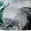 Tropical Storm Elsa – Final Update – Passing Over Virginia To Go Into the Northeastern Seaboard07/08/2021
 Featured Photo: Architecture, Part 4 – The Skies of Chicago, Illinois – South-Southeast Sunset View ...01/09/2022
 Safer Internet Day – 202302/09/2023
